
Topografische kaart Olathe
Interactieve kaart
Klik op de kaart om de hoogte weer te geven.
Over deze kaart
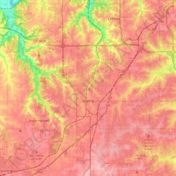
Naam: Topografische kaart Olathe, hoogte, reliëf.
Locatie: Olathe, Johnson County, Kansas, United States (38.80548 -94.92802 38.98893 -94.71440)
Gemiddelde hoogte: 309 m
Minimale hoogte: 230 m
Maximale hoogte: 342 m
Andere topografische kaarten
Klik op een kaart om zijn topografie, zijn hoogte en zijn reliëf te bekijken.
Lenexa
United States > Kansas > Johnson County
Lenexa, Johnson County, Kansas, United States
Gemiddelde hoogte: 301 m
Fairway
United States > Kansas > Johnson County
Fairway, Johnson County, Kansas, United States
Gemiddelde hoogte: 290 m
Overland Park
United States > Kansas > Johnson County
Overland Park, Johnson County, Kansas, United States
Gemiddelde hoogte: 300 m
Lenexa
United States > Kansas > Johnson County > Lenexa
Lenexa, Johnson County, Kansas, 66219, United States
Gemiddelde hoogte: 290 m
Leawood
United States > Kansas > Johnson County
Leawood, Johnson County, Kansas, United States
Gemiddelde hoogte: 289 m
Overland Park
United States > Kansas > Johnson County > Overland Park
Overland Park, Johnson County, Kansas, 66204, United States
Gemiddelde hoogte: 288 m
Prairie Village
United States > Kansas > Johnson County
Prairie Village, Johnson County, Kansas, United States
Gemiddelde hoogte: 300 m
Olathe
United States > Kansas > Johnson County > Olathe
Olathe, Johnson County, Kansas, 66061, United States
Gemiddelde hoogte: 302 m