
Topografische kaart Moses Coulee
Interactieve kaart
Klik op de kaart om de hoogte weer te geven.
Over deze kaart
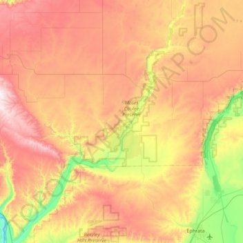
Naam: Topografische kaart Moses Coulee, hoogte, reliëf.
Gemiddelde hoogte: 665 m
Minimale hoogte: 172 m
Maximale hoogte: 1.198 m
Andere topografische kaarten
Klik op een kaart om zijn topografie, zijn hoogte en zijn reliëf te bekijken.
Palisades
United States > Washington > Douglas County
Palisades, Douglas County, Washington, 98845, United States
Gemiddelde hoogte: 482 m
Bridgeport
United States > Washington > Douglas County
Bridgeport, Douglas County, Washington, 98813, United States
Gemiddelde hoogte: 313 m
Orondo
United States > Washington > Douglas County
Orondo, Douglas County, Washington, United States
Gemiddelde hoogte: 386 m
Rock Island
United States > Washington > Douglas County
Rock Island, Douglas County, Washington, 98850, United States
Gemiddelde hoogte: 214 m
Mansfield
United States > Washington > Douglas County
Mansfield, Douglas County, Washington, United States
Gemiddelde hoogte: 690 m
Waterville
United States > Washington > Douglas County
Waterville, Douglas County, Washington, 98858, United States
Gemiddelde hoogte: 807 m
East Wenatchee Bench
United States > Washington > Douglas County > East Wenatchee
East Wenatchee Bench, East Wenatchee, Douglas County, Washington, 98802, United States
Gemiddelde hoogte: 296 m
Sunny Beach
United States > Washington > Douglas County
Sunny Beach, Douglas County, Washington, United States
Gemiddelde hoogte: 220 m
East Wenatchee
United States > Washington > Douglas County
East Wenatchee, Douglas County, Washington, 98802, United States
Gemiddelde hoogte: 249 m