
Doe een donatie
Rust jezelf uit voor je volgende avontuur:
Als Amazon-partner verdient deze site een commissie op in aanmerking komende aankopen, zonder extra kosten voor jou.
Topografische kaart Rock Island
Klik op de kaart om de hoogte weer te geven.
Doe een donatie
Rust jezelf uit voor je volgende avontuur:
Als Amazon-partner verdient deze site een commissie op in aanmerking komende aankopen, zonder extra kosten voor jou.
Over deze kaart
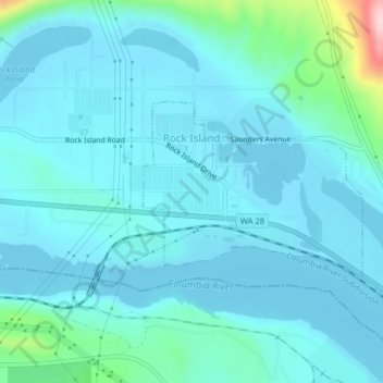
Naam: Topografische kaart Rock Island, hoogte, reliëf.
Locatie: Rock Island, Douglas County, Washington, United States (47.36691 -120.14913 47.37966 -120.12614)
Gemiddelde hoogte: 214 m
Minimale hoogte: 185 m
Maximale hoogte: 420 m
Doe een donatie
Rust jezelf uit voor je volgende avontuur:
Als Amazon-partner verdient deze site een commissie op in aanmerking komende aankopen, zonder extra kosten voor jou.
Andere topografische kaarten
Klik op een kaart om zijn topografie, zijn hoogte en zijn reliëf te bekijken.
Doe een donatie
Rust jezelf uit voor je volgende avontuur:
Als Amazon-partner verdient deze site een commissie op in aanmerking komende aankopen, zonder extra kosten voor jou.
Moses Coulee
United States > Washington > Douglas County
Pleistocene glaciers advanced onto the Waterville Plateau, with the Okanogan Lobe of the Cordilleran Ice Sheet reaching as far south as the town of Withrow. Evidence for glaciation on the Waterville Plateau includes polished and striated bedrock, glacial erratics, drumlinoid topography, eskers, moraines,…
Gemiddelde hoogte: 666 m