
Topografische kaart Castle Valley
Interactieve kaart
Klik op de kaart om de hoogte weer te geven.
Over deze kaart
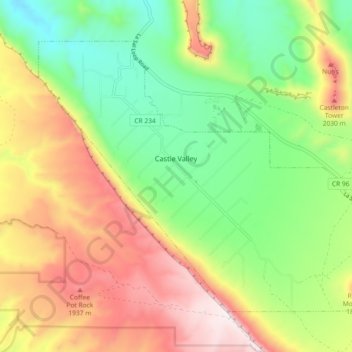
Naam: Topografische kaart Castle Valley, hoogte, reliëf.
Locatie: Castle Valley, Grand County, Utah, United States (38.60833 -109.44475 38.66322 -109.35336)
Gemiddelde hoogte: 1.610 m
Minimale hoogte: 1.265 m
Maximale hoogte: 2.067 m
Andere topografische kaarten
Klik op een kaart om zijn topografie, zijn hoogte en zijn reliëf te bekijken.
Moab
United States > Utah > Grand County
Moab, Grand County, Utah, 84532, United States
Gemiddelde hoogte: 1.357 m
Manns Peak
United States > Utah > Grand County
Manns Peak, Grand County, Utah, United States
Gemiddelde hoogte: 3.427 m
Castleton Tower
United States > Utah > Grand County
Castleton Tower, Grand County, Utah, United States
Gemiddelde hoogte: 1.549 m
Arches National Park
United States > Utah > Grand County
Arches National Park, Grand County, Utah, United States
Gemiddelde hoogte: 1.476 m