
Topografische kaart Arches National Park
Interactieve kaart
Klik op de kaart om de hoogte weer te geven.
Over deze kaart
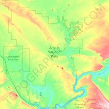
Naam: Topografische kaart Arches National Park, hoogte, reliëf.
Locatie: Arches National Park, Grand County, Utah, United States (38.60474 -109.71320 38.84693 -109.47771)
Gemiddelde hoogte: 1.476 m
Minimale hoogte: 1.206 m
Maximale hoogte: 1.995 m
The park consists of 310.31 square kilometres (76,680 acres; 119.81 sq mi; 31,031 ha) of high desert located on the Colorado Plateau. The highest elevation in the park is 5,653 feet (1,723 m) at Elephant Butte, and the lowest elevation is 4,085 feet (1,245 m) at the visitor center. The park receives an average of less than 10 inches (250 mm) of rain annually.
Andere topografische kaarten
Klik op een kaart om zijn topografie, zijn hoogte en zijn reliëf te bekijken.
Moab
United States > Utah > Grand County
Moab, Grand County, Utah, 84532, United States
Gemiddelde hoogte: 1.357 m
Manns Peak
United States > Utah > Grand County
Manns Peak, Grand County, Utah, United States
Gemiddelde hoogte: 3.427 m
Castle Valley
United States > Utah > Grand County
Castle Valley, Grand County, Utah, United States
Gemiddelde hoogte: 1.610 m
Castleton Tower
United States > Utah > Grand County
Castleton Tower, Grand County, Utah, United States
Gemiddelde hoogte: 1.549 m