
Topografische kaart Fort Peck
Interactieve kaart
Klik op de kaart om de hoogte weer te geven.
Over deze kaart
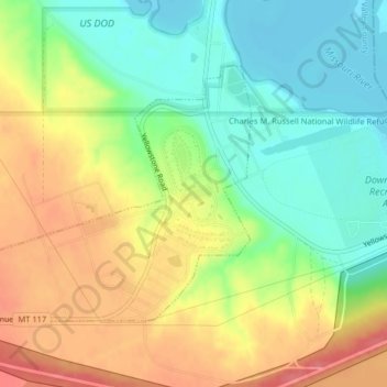
Naam: Topografische kaart Fort Peck, hoogte, reliëf.
Locatie: Fort Peck, Valley County, Montana, United States (48.00077 -106.47954 48.01857 -106.44172)
Gemiddelde hoogte: 652 m
Minimale hoogte: 618 m
Maximale hoogte: 693 m
Andere topografische kaarten
Klik op een kaart om zijn topografie, zijn hoogte en zijn reliëf te bekijken.
Fort Peck Lake
United States > Montana > Valley County
Fort Peck Lake, Valley County, Montana, 59223, United States
Gemiddelde hoogte: 783 m
Dead Mans Hill
United States > Montana > Valley County
Dead Mans Hill, Valley County, Montana, United States
Gemiddelde hoogte: 728 m
Glasgow
United States > Montana > Valley County > Glasgow
Glasgow, Valley County, Montana, 59230, United States
Gemiddelde hoogte: 654 m