
Topografische kaart Youyu County
Interactieve kaart
Klik op de kaart om de hoogte weer te geven.
Over deze kaart
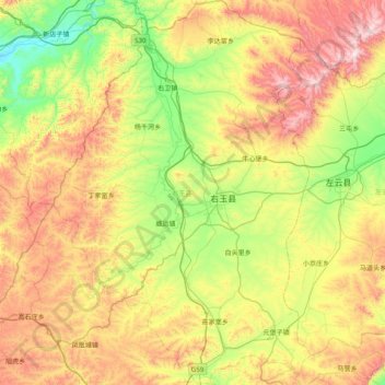
Naam: Topografische kaart Youyu County, hoogte, reliëf.
Locatie: Youyu County, Shuozhou City, Shanxi, China (39.69259 112.11211 40.29863 112.64180)
Gemiddelde hoogte: 1.486 m
Minimale hoogte: 1.130 m
Maximale hoogte: 2.058 m
Elevations are generally higher in the south of the county, in which flows the Cangtou River (苍头河); Youyu reaches a north-south extent of 67.7 km (42.1 mi) and east-west width of 45.7 km (28.4 mi). The Great Wall demarcates the northwestern border with Inner Mongolia's Liangcheng and Horinger counties; within the province, Youyu borders Zuoyun County to the east, Shanyin County and Pinglu District to the south.
Andere topografische kaarten
Klik op een kaart om zijn topografie, zijn hoogte en zijn reliëf te bekijken.
Pingyao County
China > Shanxi > Jinzhong City
Pingyao County, Jinzhong City, Shanxi, 031100, China
Gemiddelde hoogte: 1.128 m
Hejin
China > Shanxi > Hejin City > Chengqu Subdistrict
Hejin, Chengqu Subdistrict, Hejin City, Yuncheng City, Shanxi, 043300, China
Gemiddelde hoogte: 529 m
Linyi
China > Shanxi > Linyi County
Linyi, Linyi County, Yuncheng City, Shanxi, China
Gemiddelde hoogte: 455 m
Shiba
China > Shanxi > Ningwu County > Shiba
Shiba, Ningwu County, Xinzhou City, Shanxi, China
Gemiddelde hoogte: 1.599 m
Pingcheng District
China > Shanxi > Pingcheng District
Datong, Pingcheng District, Datong City, Shanxi, 037004, China
Gemiddelde hoogte: 1.149 m
Gulou Subdistrict
China > Shanxi > Gulou Subdistrict
Gulou Subdistrict, Huozhou City, Linfen Shi, Shanxi, China
Gemiddelde hoogte: 560 m
Yuncheng
China > Shanxi > Dongcheng Subdistrict
Yuncheng, Dongcheng Subdistrict, Yanhu District, Yuncheng City, Shanxi, 044031, China
Gemiddelde hoogte: 478 m