
Topografische kaart Datong
Interactieve kaart
Klik op de kaart om de hoogte weer te geven.
Over deze kaart
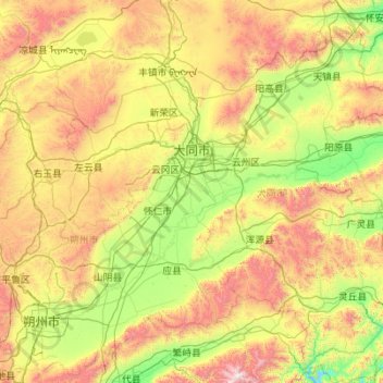
Naam: Topografische kaart Datong, hoogte, reliëf.
Locatie: Datong, Shanxi, China (39.04845 112.57067 40.74496 114.56551)
Gemiddelde hoogte: 1.339 m
Minimale hoogte: 690 m
Maximale hoogte: 3.029 m
Datong is a prefecture-level city in northern Shanxi Province in the People's Republic of China. It is located in the Datong Basin at an elevation of 1,040 metres (3,410 ft) and borders Inner Mongolia to the north and west and Hebei to the east. As of the 2020 census, it had a population of 3,105,591 of whom 1,790,452 lived in the built-up (or metro) area made of the 2 out 4 urban districts of Pingcheng and Yungang as Yunzhou and Xinrong are not conurbated yet.
Andere topografische kaarten
Klik op een kaart om zijn topografie, zijn hoogte en zijn reliëf te bekijken.
Pingyao County
China > Shanxi > Jinzhong City
Pingyao County, Jinzhong City, Shanxi, 031100, China
Gemiddelde hoogte: 1.128 m
Hejin
China > Shanxi > Hejin City > Chengqu Subdistrict
Hejin, Chengqu Subdistrict, Hejin City, Yuncheng City, Shanxi, 043300, China
Gemiddelde hoogte: 529 m
Linyi
China > Shanxi > Linyi County
Linyi, Linyi County, Yuncheng City, Shanxi, China
Gemiddelde hoogte: 455 m
Shiba
China > Shanxi > Ningwu County > Shiba
Shiba, Ningwu County, Xinzhou City, Shanxi, China
Gemiddelde hoogte: 1.599 m
Pingcheng District
China > Shanxi > Pingcheng District
Datong, Pingcheng District, Datong City, Shanxi, 037004, China
Gemiddelde hoogte: 1.149 m
Gulou Subdistrict
China > Shanxi > Gulou Subdistrict
Gulou Subdistrict, Huozhou City, Linfen Shi, Shanxi, China
Gemiddelde hoogte: 560 m
Yuncheng
China > Shanxi > Dongcheng Subdistrict
Yuncheng, Dongcheng Subdistrict, Yanhu District, Yuncheng City, Shanxi, 044031, China
Gemiddelde hoogte: 478 m