
Topografische kaart Villanúa
Interactieve kaart
Klik op de kaart om de hoogte weer te geven.
Over deze kaart
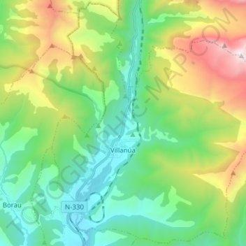
Naam: Topografische kaart Villanúa, hoogte, reliëf.
Locatie: Villanúa, Jacetania, Huesca, Aragon, 22870, Spain (42.64379 -0.56716 42.73401 -0.44207)
Gemiddelde hoogte: 1.499 m
Minimale hoogte: 895 m
Maximale hoogte: 2.872 m
Villanúa (in Aragonese: Bellanuga[1][2]) is a Pyrenean municipality in Spain in the north of Huesca province, in la Jacetania, set where the Aragon valley gets wider. Its name refers to the "new village" repopulated in the late 10th century. Villanúa's altitude is 953 m and it covers 58.2 km2. The village is at the bottom of mount Collarada (2886 m) and in 2018 had 447 inhabitants.
Andere topografische kaarten
Klik op een kaart om zijn topografie, zijn hoogte en zijn reliëf te bekijken.