
Topografische kaart Canfranc
Interactieve kaart
Klik op de kaart om de hoogte weer te geven.
Over deze kaart
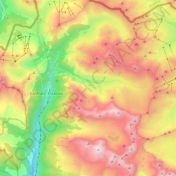
Naam: Topografische kaart Canfranc, hoogte, reliëf.
Locatie: Canfranc, Jacetania, Huesca, Aragon, 22880, Spain (42.69725 -0.53755 42.80944 -0.42112)
Gemiddelde hoogte: 1.862 m
Minimale hoogte: 994 m
Maximale hoogte: 2.872 m
The village, which lies in the valley of the Aragón River, covers an area of 71.6 km2 (27.6 sq mi) and is situated at an altitude of 1,040 m (3,410 ft). The remains to be seen include a Romanesque pilgrim's bridge and two churches of interest: Nuestra Señora de la Asunción (12th to 16th centuries) with four baroque retablos, and La Trinidad (16th century). The town was obliterated by fire in 1617 and again in 1944, after which the villagers for the most part moved to nearby Canfranc Station. The current population is 77.
Andere topografische kaarten
Klik op een kaart om zijn topografie, zijn hoogte en zijn reliëf te bekijken.