
Doe een donatie
Rust jezelf uit voor je volgende avontuur:
Als Amazon-partner verdient deze site een commissie op in aanmerking komende aankopen, zonder extra kosten voor jou.
Topografische kaart Artic
Klik op de kaart om de hoogte weer te geven.
Doe een donatie
Rust jezelf uit voor je volgende avontuur:
Als Amazon-partner verdient deze site een commissie op in aanmerking komende aankopen, zonder extra kosten voor jou.
Over deze kaart
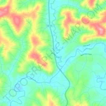
Naam: Topografische kaart Artic, hoogte, reliëf.
Locatie: Artic, Grays Harbor County, Washington, United States (46.87032 -123.73528 46.91032 -123.69528)
Gemiddelde hoogte: 75 m
Minimale hoogte: 22 m
Maximale hoogte: 175 m
Doe een donatie
Rust jezelf uit voor je volgende avontuur:
Als Amazon-partner verdient deze site een commissie op in aanmerking komende aankopen, zonder extra kosten voor jou.
Andere topografische kaarten
Klik op een kaart om zijn topografie, zijn hoogte en zijn reliëf te bekijken.
Ocean Shores
United States > Washington > Grays Harbor County
Ocean Shores is set on relatively flat coastal terrain. The city's elevation averages about 10 to 15 feet (3 to 5 meters) above sea level, typical for much of the Washington coast's beach communities. It sits on a spit of land between the Pacific Ocean to the west and Grays Harbor to the east. This unique…
Gemiddelde hoogte: 1 m
Aberdeen
United States > Washington > Grays Harbor County
Aberdeen is at the eastern end of Grays Harbor, near the mouth of the Chehalis River and southwest of the Olympic Mountains. Grays Harbor is notable as the northernmost ria on North America's Pacific Coast because it has remained free of glaciers throughout the Quaternary due to unfavorable topography and warm…
Gemiddelde hoogte: 48 m
Doe een donatie
Rust jezelf uit voor je volgende avontuur:
Als Amazon-partner verdient deze site een commissie op in aanmerking komende aankopen, zonder extra kosten voor jou.
Doe een donatie
Rust jezelf uit voor je volgende avontuur:
Als Amazon-partner verdient deze site een commissie op in aanmerking komende aankopen, zonder extra kosten voor jou.
Copalis Beach
United States > Washington > Grays Harbor County > Copalis Beach
Gemiddelde hoogte: 13 m
Roosevelt Beach Conservation Area
United States > Washington > Grays Harbor County > Ocean Grove
Gemiddelde hoogte: 18 m
Doe een donatie
Rust jezelf uit voor je volgende avontuur:
Als Amazon-partner verdient deze site een commissie op in aanmerking komende aankopen, zonder extra kosten voor jou.
Copalis Beach
United States > Washington > Grays Harbor County > Copalis Beach
Gemiddelde hoogte: 13 m
Doe een donatie
Rust jezelf uit voor je volgende avontuur:
Als Amazon-partner verdient deze site een commissie op in aanmerking komende aankopen, zonder extra kosten voor jou.
Aberdeen
United States > Washington > Grays Harbor County
Aberdeen is at the eastern end of Grays Harbor, near the mouth of the Chehalis River and southwest of the Olympic Mountains. Grays Harbor is notable as the northernmost ria on North America's Pacific Coast because it has remained free of glaciers throughout the Quaternary due to unfavorable topography and warm…
Gemiddelde hoogte: 48 m
Doe een donatie
Rust jezelf uit voor je volgende avontuur:
Als Amazon-partner verdient deze site een commissie op in aanmerking komende aankopen, zonder extra kosten voor jou.
Roosevelt Beach Conservation Area
United States > Washington > Grays Harbor County > Ocean Grove
Gemiddelde hoogte: 18 m
Doe een donatie
Rust jezelf uit voor je volgende avontuur:
Als Amazon-partner verdient deze site een commissie op in aanmerking komende aankopen, zonder extra kosten voor jou.