Geolokaliseren

Topografische kaart Humptulips

Interactieve kaart

Klik op de kaart om de hoogte weer te geven.

Over deze kaart

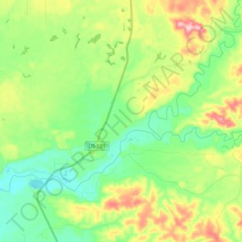
Naam: Topografische kaart Humptulips, hoogte, reliëf.

Locatie: Humptulips, Grays Harbor County, Washington, United States (47.21916 -124.01160 47.29106 -123.85437)

Gemiddelde hoogte: 108 m

Minimale hoogte: 24 m

Maximale hoogte: 270 m

Andere topografische kaarten

Klik op een kaart om zijn topografie, zijn hoogte en zijn reliëf te bekijken.

Vesta

United States > Washington > Grays Harbor County

Vesta, Grays Harbor County, Washington, United States

Gemiddelde hoogte: 86 m

Roosevelt Beach Conservation Area

United States > Washington > Grays Harbor County > Ocean Grove

Roosevelt Beach Conservation Area, Ocean Grove, Grays Harbor County, Washington, United States

Gemiddelde hoogte: 18 m

Artic

United States > Washington > Grays Harbor County

Artic, Grays Harbor County, Washington, United States

Gemiddelde hoogte: 75 m

Grisdale

United States > Washington > Grays Harbor County

Grisdale, Grays Harbor County, Washington, United States

Gemiddelde hoogte: 354 m

Elma

United States > Washington > Grays Harbor County > Elma

Elma, Grays Harbor County, Washington, United States

Gemiddelde hoogte: 36 m

Ocean Shores

United States > Washington > Grays Harbor County

Ocean Shores, Grays Harbor County, Washington, 98569, United States

Gemiddelde hoogte: 1 m

McCleary

United States > Washington > Grays Harbor County > McCleary > McCleary

McCleary, Grays Harbor County, Washington, 98557, United States

Gemiddelde hoogte: 108 m