
Topografische kaart Vesta
Klik op de kaart om de hoogte weer te geven.
Over deze kaart
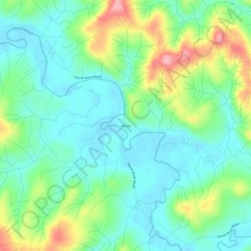
Naam: Topografische kaart Vesta, hoogte, reliëf.
Locatie: Vesta, Grays Harbor County, Washington, United States (46.81315 -123.60877 46.85315 -123.56877)
Gemiddelde hoogte: 86 m
Minimale hoogte: 35 m
Maximale hoogte: 208 m
Andere topografische kaarten
Klik op een kaart om zijn topografie, zijn hoogte en zijn reliëf te bekijken.
Ocean Shores
United States > Washington > Grays Harbor County
Ocean Shores is set on relatively flat coastal terrain. The city's elevation averages about 10 to 15 feet (3 to 5 meters) above sea level, typical for much of the Washington coast's beach communities. It sits on a spit of land between the Pacific Ocean to the west and Grays Harbor to the east. This unique…
Gemiddelde hoogte: 1 m
Aberdeen
United States > Washington > Grays Harbor County
Aberdeen is at the eastern end of Grays Harbor, near the mouth of the Chehalis River and southwest of the Olympic Mountains. Grays Harbor is notable as the northernmost ria on North America's Pacific Coast because it has remained free of glaciers throughout the Quaternary due to unfavorable topography and warm…
Gemiddelde hoogte: 48 m
Copalis Beach
United States > Washington > Grays Harbor County > Copalis Beach
Gemiddelde hoogte: 13 m
Roosevelt Beach Conservation Area
United States > Washington > Grays Harbor County > Ocean Grove
Gemiddelde hoogte: 18 m
Ocean Shores
United States > Washington > Grays Harbor County
The Point Brown Peninsula is entirely occupied by Ocean Shores and portions of Oyehut. It is 6,000 acres (2,400 ha) in area, and acts as a breakwater to the entrance of Grays Harbor, the estuary of the Chehalis River. Similar to the Long Beach Peninsula, the Point Brown Peninsula is at high risk of destruction…
Gemiddelde hoogte: 1 m
Copalis Beach
United States > Washington > Grays Harbor County > Copalis Beach
Gemiddelde hoogte: 13 m
Aberdeen
United States > Washington > Grays Harbor County
Aberdeen is at the eastern end of Grays Harbor, near the mouth of the Chehalis River and southwest of the Olympic Mountains. Grays Harbor is notable as the northernmost ria on North America's Pacific Coast because it has remained free of glaciers throughout the Quaternary due to unfavorable topography and warm…
Gemiddelde hoogte: 48 m
Roosevelt Beach Conservation Area
United States > Washington > Grays Harbor County > Ocean Grove
Gemiddelde hoogte: 18 m