
Topografische kaart Camino
Interactieve kaart
Klik op de kaart om de hoogte weer te geven.
Over deze kaart
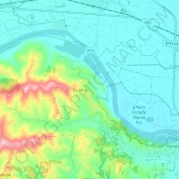
Naam: Topografische kaart Camino, hoogte, reliëf.
Locatie: Camino, Alessandria, Piedmont, Italy (45.14341 8.23664 45.18109 8.32158)
Gemiddelde hoogte: 179 m
Minimale hoogte: 116 m
Maximale hoogte: 369 m
Andere topografische kaarten
Klik op een kaart om zijn topografie, zijn hoogte en zijn reliëf te bekijken.
Silver poplar
Italy > Piedmont > Alessandria > Castelnuovo Scrivia > Il Secco
Silver poplar, Strada Secco, Il Secco, Castelnuovo Scrivia, Alessandria, Piedmont, 15053, Italy
Gemiddelde hoogte: 79 m
Isola Sant'Antonio
Italy > Piedmont > Alessandria
Isola Sant'Antonio, Alessandria, Piedmont, Italy
Gemiddelde hoogte: 76 m
Incisa
Italy > Piedmont > Alessandria > Montacuto
Incisa, Montacuto, Alessandria, Piedmont, 15056, Italy
Gemiddelde hoogte: 533 m
Casale Monferrato
Italy > Piedmont > Alessandria
Casale Monferrato, Alessandria, Piedmont, 15033, Italy
Gemiddelde hoogte: 142 m
Masio
Italy > Piedmont > Alessandria
Masio, Alessandria, Piedmont, 15024, Italy
Gemiddelde hoogte: 129 m
Serravalle Scrivia
Italy > Piedmont > Alessandria
Serravalle Scrivia, Alessandria, Piedmont, 15069, Italy
Gemiddelde hoogte: 262 m