
Topografische kaart Casale Monferrato
Interactieve kaart
Klik op de kaart om de hoogte weer te geven.
Over deze kaart
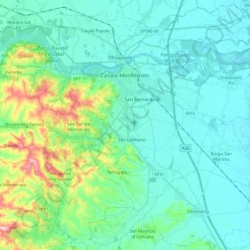
Naam: Topografische kaart Casale Monferrato, hoogte, reliëf.
Locatie: Casale Monferrato, Alessandria, Piedmont, 15033, Italy (45.04102 8.35945 45.17566 8.55704)
Gemiddelde hoogte: 142 m
Minimale hoogte: 97 m
Maximale hoogte: 338 m
At the south-east corner of the piazza is the elegant Baroque church of Santa Maria delle Grazie, better known by its earlier designation of Santa Caterina. A master-work of Giovanni Battista Scapitta, completed after his death by Giacomo Zanetti, it is marked by an elliptical cupola, and a façade curvilinear both in plan and elevation.
Andere topografische kaarten
Klik op een kaart om zijn topografie, zijn hoogte en zijn reliëf te bekijken.
Silver poplar
Italy > Piedmont > Alessandria > Castelnuovo Scrivia > Il Secco
Silver poplar, Strada Secco, Il Secco, Castelnuovo Scrivia, Alessandria, Piedmont, 15053, Italy
Gemiddelde hoogte: 79 m
Isola Sant'Antonio
Italy > Piedmont > Alessandria
Isola Sant'Antonio, Alessandria, Piedmont, Italy
Gemiddelde hoogte: 76 m
Incisa
Italy > Piedmont > Alessandria > Montacuto
Incisa, Montacuto, Alessandria, Piedmont, 15056, Italy
Gemiddelde hoogte: 533 m
Masio
Italy > Piedmont > Alessandria
Masio, Alessandria, Piedmont, 15024, Italy
Gemiddelde hoogte: 129 m
Serravalle Scrivia
Italy > Piedmont > Alessandria
Serravalle Scrivia, Alessandria, Piedmont, 15069, Italy
Gemiddelde hoogte: 262 m