
Doe een donatie
Rust jezelf uit voor je volgende avontuur:
Als Amazon-partner verdient deze site een commissie op in aanmerking komende aankopen, zonder extra kosten voor jou.
Topografische kaart Lead
Klik op de kaart om de hoogte weer te geven.
Doe een donatie
Rust jezelf uit voor je volgende avontuur:
Als Amazon-partner verdient deze site een commissie op in aanmerking komende aankopen, zonder extra kosten voor jou.
Lead
Its high elevation in the Black Hills makes Lead one of the wettest places in South Dakota and among the snowiest places in the contiguous United States with a mean snowfall of 183.9 inches or 4.67 metres. During the cold and snowy winter of 1993–94, a whopping 364.7 inches (9.26 m) of snow fell and three years later snowfall totalled 324.0 inches (8.23 m). However, frequent chinook winds mean that most of the enormous snowfall melts during the winter: the highest snow cover on record is 73 inches (1.85 m) on March 1, 1998 – during a storm that totalled 114.6 inches or 2.91 metres of snow (water equivalent 4.12 inches or 104.6 millimetres) over six days ending March 2. Mean snow depth in January is only 7 inches or 0.18 metres and the median even less at 5 inches or 0.13 metres. 12.9 mornings can be expected to fall to or below 0 °F (−17.8 °C), with the average window for zero temperatures being December 7 to March 3; on the other hand during winter 12.8 afternoons can be expected to get to or above 50 °F or 10 °C. The coldest temperature has been −40 °F or −40 °C on February 8, 1936.
Doe een donatie
Rust jezelf uit voor je volgende avontuur:
Als Amazon-partner verdient deze site een commissie op in aanmerking komende aankopen, zonder extra kosten voor jou.
Over deze kaart
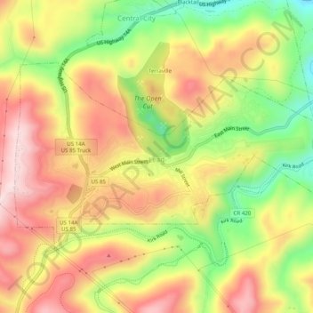
Naam: Topografische kaart Lead, hoogte, reliëf.
Locatie: Lead, Lawrence County, South Dakota, United States (44.34184 -103.78764 44.36313 -103.73826)
Gemiddelde hoogte: 1.605 m
Minimale hoogte: 1.417 m
Maximale hoogte: 1.764 m
Doe een donatie
Rust jezelf uit voor je volgende avontuur:
Als Amazon-partner verdient deze site een commissie op in aanmerking komende aankopen, zonder extra kosten voor jou.
Andere topografische kaarten
Klik op een kaart om zijn topografie, zijn hoogte en zijn reliëf te bekijken.
Doe een donatie
Rust jezelf uit voor je volgende avontuur:
Als Amazon-partner verdient deze site een commissie op in aanmerking komende aankopen, zonder extra kosten voor jou.