
Doe een donatie
Rust jezelf uit voor je volgende avontuur:
Als Amazon-partner verdient deze site een commissie op in aanmerking komende aankopen, zonder extra kosten voor jou.
Topografische kaart Terry Peak
Klik op de kaart om de hoogte weer te geven.
Doe een donatie
Rust jezelf uit voor je volgende avontuur:
Als Amazon-partner verdient deze site een commissie op in aanmerking komende aankopen, zonder extra kosten voor jou.
Over deze kaart
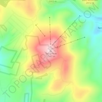
Naam: Topografische kaart Terry Peak, hoogte, reliëf.
Locatie: Terry Peak, Lawrence County, South Dakota, United States (44.32743 -103.83525 44.32753 -103.83515)
Gemiddelde hoogte: 1.940 m
Minimale hoogte: 1.769 m
Maximale hoogte: 2.148 m
Doe een donatie
Rust jezelf uit voor je volgende avontuur:
Als Amazon-partner verdient deze site een commissie op in aanmerking komende aankopen, zonder extra kosten voor jou.
Andere topografische kaarten
Klik op een kaart om zijn topografie, zijn hoogte en zijn reliëf te bekijken.
Deadwood
United States > South Dakota > Lawrence County
Deadwood is characterized by its rugged terrain nestled within the Black Hills region, boasting an elevation of approximately 4,531 feet. The town itself is set in a steep, narrow gulch surrounded by densely forested hills, which create a dramatic landscape of rolling hills and rocky outcrops. The topography…
Gemiddelde hoogte: 1.511 m
Spearfish
United States > South Dakota > Lawrence County
Extreme winter maxima in the district are remarkably warm given the latitude and altitude; on January 19, 1921 Spearfish reached a temperature of 79 °F (26 °C), the hottest January temperature in South Dakota on record.
Gemiddelde hoogte: 1.171 m
Lead
United States > South Dakota > Lawrence County
Its high elevation in the Black Hills makes Lead one of the wettest places in South Dakota and among the snowiest places in the contiguous United States with a mean snowfall of 183.9 inches or 4.67 metres. During the cold and snowy winter of 1993–94, a whopping 364.7 inches (9.26 m) of snow fell and three…
Gemiddelde hoogte: 1.605 m
Doe een donatie
Rust jezelf uit voor je volgende avontuur:
Als Amazon-partner verdient deze site een commissie op in aanmerking komende aankopen, zonder extra kosten voor jou.
Lead
United States > South Dakota > Lawrence County
Its high elevation in the Black Hills makes Lead one of the wettest places in South Dakota and among the snowiest places in the contiguous United States with a mean snowfall of 183.9 inches or 4.67 metres. During the cold and snowy winter of 1993–94, a whopping 364.7 inches (9.26 m) of snow fell and three…
Gemiddelde hoogte: 1.605 m
Spearfish
United States > South Dakota > Lawrence County
Extreme winter maxima in the district are remarkably warm given the latitude and altitude; on January 19, 1921, Spearfish reached a temperature of 79 °F (26 °C), the hottest January temperature in South Dakota on record.
Gemiddelde hoogte: 1.171 m
Doe een donatie
Rust jezelf uit voor je volgende avontuur:
Als Amazon-partner verdient deze site een commissie op in aanmerking komende aankopen, zonder extra kosten voor jou.