
Topografische kaart Emery County
Interactieve kaart
Klik op de kaart om de hoogte weer te geven.
Over deze kaart
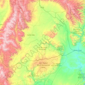
Naam: Topografische kaart Emery County, hoogte, reliëf.
Locatie: Emery County, Utah, United States (38.49993 -111.30708 39.70435 -109.98790)
Gemiddelde hoogte: 1.958 m
Minimale hoogte: 1.205 m
Maximale hoogte: 3.472 m
In 1853 John W. Gunnison, an Army Topographical Engineer came through Castle Valley, plotting a railroad route. He was commissioned for this assignment by the US Secretary of War Jefferson Davis. He left detailed descriptions of his travels and carefully laid out his route through Castle Valley. Gunnison's route first met the Spanish Trail at the Green River crossing. He followed this trail for a short distance west of the Green River, but when the Spanish Trail entered a rugged rocky region (Sinbad Reef) he charted a route around this feature.
Andere topografische kaarten
Klik op een kaart om zijn topografie, zijn hoogte en zijn reliëf te bekijken.
Tyler
United States > Utah > Salt Lake County > Murray
Tyler, South Cottonwood Acres, Murray, Salt Lake County, Utah, 84117, United States
Gemiddelde hoogte: 1.334 m
Ophir
United States > Utah > Tooele County
Ophir, Tooele County, Utah, United States
Gemiddelde hoogte: 2.232 m
Sandy
United States > Utah > Salt Lake County
Sandy, Salt Lake County, Utah, United States
Gemiddelde hoogte: 1.376 m
drainage
United States > Utah > Salt Lake County > West Jordan
drainage, West Jordan, Salt Lake County, Utah, United States
Gemiddelde hoogte: 1.389 m
Bayview Heights
United States > Utah > Davis County > Farmington
Bayview Heights, Farmington, Davis County, Utah, 84025, United States
Gemiddelde hoogte: 1.457 m
Virgin
United States > Utah > Washington County
Virgin, Washington County, Utah, United States
Gemiddelde hoogte: 1.251 m
Axtell
United States > Utah > Sanpete County
Axtell, Sanpete County, Utah, 84621, United States
Gemiddelde hoogte: 1.572 m
Park City
United States > Utah > Summit County
Park City, Summit County, Utah, United States
Gemiddelde hoogte: 2.290 m
Kimball Junction
United States > Utah > Summit County
Kimball Junction, Summit County, Utah, 84098, United States
Gemiddelde hoogte: 2.004 m
Bear River
United States > Utah > Rich County
Bear River, Rich County, Utah, 84086, United States
Gemiddelde hoogte: 1.924 m
Salt Lake City
United States > Utah > Salt Lake County > Salt Lake City
Salt Lake City, Salt Lake County, Utah, 84139, United States
Gemiddelde hoogte: 1.625 m
Solitude
United States > Utah > Salt Lake County > Solitude
Solitude, Salt Lake County, Utah, United States
Gemiddelde hoogte: 2.706 m
Paria Canyon
Paria Canyon, Kane County, Utah, United States
Gemiddelde hoogte: 1.581 m
Aquarius Plateau
United States > Utah > Garfield County
Aquarius Plateau, Garfield County, Utah, United States
Gemiddelde hoogte: 3.024 m
Colorado Plateau
United States > Utah > San Juan County
Colorado Plateau, San Juan County, Utah, United States
Gemiddelde hoogte: 1.512 m
Jensen
United States > Utah > Uintah County > Jensen
Jensen, Uintah County, Utah, 84035, United States
Gemiddelde hoogte: 1.470 m
Moab
United States > Utah > Grand County
Moab, Grand County, Utah, 84532, United States
Gemiddelde hoogte: 1.357 m
Midvale
United States > Utah > Midvale
Midvale, Salt Lake County, Utah, 84047, United States
Gemiddelde hoogte: 1.335 m
Farmington Heights
United States > Utah > Farmington > Farmington Heights
Farmington Heights, Farmington, Davis County, Utah, 84025, United States
Gemiddelde hoogte: 1.511 m
Paria River
Paria River, Kane County, Utah, 84718, United States
Gemiddelde hoogte: 1.802 m
West Jordan
United States > Utah > West Jordan
West Jordan, Salt Lake County, Utah, United States
Gemiddelde hoogte: 1.372 m
Salt Lake City
United States > Utah > Salt Lake County
Salt Lake City, Salt Lake County, Utah, United States
Gemiddelde hoogte: 1.592 m
Mount Nebo
United States > Utah > Juab County
Mount Nebo, Juab County, Utah, United States
Gemiddelde hoogte: 3.115 m
South Jordan
United States > Utah > South Jordan
South Jordan, Salt Lake County, Utah, United States
Gemiddelde hoogte: 1.383 m
Provo
United States > Utah > Utah County
Provo, Utah County, Utah, United States
Gemiddelde hoogte: 1.728 m
Zion National Park
United States > Utah > Washington County
Zion National Park, Washington County, Utah, United States
Gemiddelde hoogte: 1.877 m