
Topografische kaart Te Hāpua Waikawa / Lake Lyndon
Interactieve kaart
Klik op de kaart om de hoogte weer te geven.
Over deze kaart
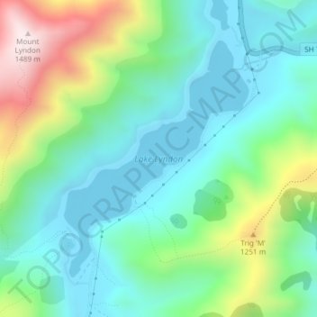
Naam: Topografische kaart Te Hāpua Waikawa / Lake Lyndon, hoogte, reliëf.
Gemiddelde hoogte: 1.012 m
Minimale hoogte: 827 m
Maximale hoogte: 1.488 m
Lake Lyndon is a small lake in the Canterbury region of New Zealand's South Island. It is located near Porters Pass on State Highway 73 after Springfield heading into the Southern Alps. The lake regularly freezes in winter due to its elevation and location on the outer border of the Southern Alps.
Andere topografische kaarten
Klik op een kaart om zijn topografie, zijn hoogte en zijn reliëf te bekijken.
Springfield
New Zealand > Canterbury > Selwyn District
Springfield, Selwyn District, Canterbury, 7649, New Zealand
Gemiddelde hoogte: 396 m
Prebbleton
New Zealand > Canterbury > Selwyn District
Prebbleton, Selwyn District, Canterbury, 7604, New Zealand
Gemiddelde hoogte: 25 m
Windwhistle
New Zealand > Canterbury > Selwyn District
Windwhistle, Selwyn District, Canterbury, New Zealand
Gemiddelde hoogte: 434 m
Rolleston
New Zealand > Canterbury > Selwyn District
Rolleston, Selwyn District, Canterbury, 7643, New Zealand
Gemiddelde hoogte: 54 m
Castle Hill Village
New Zealand > Canterbury > Selwyn District
Castle Hill Village, Selwyn District, Canterbury, 7580, New Zealand
Gemiddelde hoogte: 787 m
Lincoln
New Zealand > Canterbury > Selwyn District
Lincoln, Selwyn District, Canterbury, 7608, New Zealand
Gemiddelde hoogte: 15 m
Sheffield
New Zealand > Canterbury > Selwyn District
Sheffield, Selwyn District, Canterbury, 7500, New Zealand
Gemiddelde hoogte: 309 m
West Melton
New Zealand > Canterbury > Selwyn District
West Melton, Selwyn District, Canterbury, 7618, New Zealand
Gemiddelde hoogte: 88 m
Tai Tapu
New Zealand > Canterbury > Selwyn District
Tai Tapu, Selwyn District, Canterbury, 7672, New Zealand
Gemiddelde hoogte: 21 m
Dunsandel
New Zealand > Canterbury > Selwyn District
Dunsandel, Selwyn District, Canterbury, 7682, New Zealand
Gemiddelde hoogte: 74 m
Arthur's Pass
New Zealand > Canterbury > Selwyn District
Arthur's Pass, Selwyn District, Canterbury, 7875, New Zealand
Gemiddelde hoogte: 1.204 m
Darfield
New Zealand > Canterbury > Selwyn District
Darfield, Selwyn District, Canterbury, 7510, New Zealand
Gemiddelde hoogte: 202 m
Rakaia River
New Zealand > Canterbury > Selwyn District
Rakaia River, Selwyn District, Canterbury, New Zealand
Gemiddelde hoogte: 52 m
Selwyn
New Zealand > Canterbury > Selwyn District
Selwyn, Selwyn District, Canterbury, 7682, New Zealand
Gemiddelde hoogte: 70 m
Castle Hill Peak
New Zealand > Canterbury > Selwyn District
Castle Hill Peak, Selwyn District, Canterbury, New Zealand
Gemiddelde hoogte: 1.512 m
Leeston
New Zealand > Canterbury > Selwyn District
Leeston, Selwyn District, Canterbury, 7632, New Zealand
Gemiddelde hoogte: 22 m
Kirwee
New Zealand > Canterbury > Selwyn District
Kirwee, Selwyn District, Canterbury, New Zealand
Gemiddelde hoogte: 158 m