
Topografische kaart Darfield
Interactieve kaart
Klik op de kaart om de hoogte weer te geven.
Over deze kaart
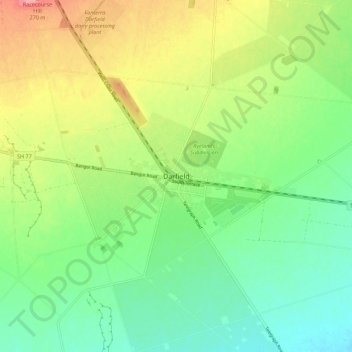
Naam: Topografische kaart Darfield, hoogte, reliëf.
Locatie: Darfield, Selwyn District, Canterbury, 7510, New Zealand (-43.52823 172.06872 -43.44823 172.14872)
Gemiddelde hoogte: 202 m
Minimale hoogte: 161 m
Maximale hoogte: 270 m
Located on the Canterbury Plains at an altitude of 193 metres (633 feet) above sea level, the Köppen-Geiger climate classification for Darfield is Cfb (Oceanic). On several days a year, Darfield is subject to the nor'west Foehn wind, which is very dry and has the capability to raise the temperature by several degrees per hour. On the contrary, the town is also susceptible to cold blasts from the Southern Ocean, especially during winter, when a southerly wind blows. The average annual temperature in Darfield is 11.6 °C (52.9 °F). The highest recorded temperature is 40.7 °C (105.3 °F), set on 8 February 1973, while the lowest recorded temperature is -8.0 °C (17.6 °F), set on 7 June 2012. The highest minimum temperature is 25.7 °C (78.3 °F), set on 6 February 2011, while the lowest maximum temperature is 0.6 °C (33.1 °F), set on 12 July 2017. On average, Darfield can expect to see 38.3 days of frost per year, and 49 days where the maximum temperature exceeds 26.7 °C (80 °F).
Andere topografische kaarten
Klik op een kaart om zijn topografie, zijn hoogte en zijn reliëf te bekijken.
Springfield
New Zealand > Canterbury > Selwyn District
Springfield, Selwyn District, Canterbury, 7649, New Zealand
Gemiddelde hoogte: 396 m
Windwhistle
New Zealand > Canterbury > Selwyn District
Windwhistle, Selwyn District, Canterbury, New Zealand
Gemiddelde hoogte: 434 m
Prebbleton
New Zealand > Canterbury > Selwyn District
Prebbleton, Selwyn District, Canterbury, 7604, New Zealand
Gemiddelde hoogte: 25 m
Rolleston
New Zealand > Canterbury > Selwyn District
Rolleston, Selwyn District, Canterbury, 7643, New Zealand
Gemiddelde hoogte: 54 m
Castle Hill Village
New Zealand > Canterbury > Selwyn District
Castle Hill Village, Selwyn District, Canterbury, 7580, New Zealand
Gemiddelde hoogte: 787 m
Lincoln
New Zealand > Canterbury > Selwyn District
Lincoln, Selwyn District, Canterbury, 7608, New Zealand
Gemiddelde hoogte: 15 m
West Melton
New Zealand > Canterbury > Selwyn District
West Melton, Selwyn District, Canterbury, 7618, New Zealand
Gemiddelde hoogte: 88 m
Sheffield
New Zealand > Canterbury > Selwyn District
Sheffield, Selwyn District, Canterbury, 7500, New Zealand
Gemiddelde hoogte: 309 m
Tai Tapu
New Zealand > Canterbury > Selwyn District
Tai Tapu, Selwyn District, Canterbury, 7672, New Zealand
Gemiddelde hoogte: 21 m
Dunsandel
New Zealand > Canterbury > Selwyn District
Dunsandel, Selwyn District, Canterbury, 7682, New Zealand
Gemiddelde hoogte: 74 m
Arthur's Pass
New Zealand > Canterbury > Selwyn District
Arthur's Pass, Selwyn District, Canterbury, 7875, New Zealand
Gemiddelde hoogte: 1.204 m
Rakaia River
New Zealand > Canterbury > Selwyn District
Rakaia River, Selwyn District, Canterbury, New Zealand
Gemiddelde hoogte: 52 m
Selwyn
New Zealand > Canterbury > Selwyn District
Selwyn, Selwyn District, Canterbury, 7682, New Zealand
Gemiddelde hoogte: 70 m
Castle Hill Peak
New Zealand > Canterbury > Selwyn District
Castle Hill Peak, Selwyn District, Canterbury, New Zealand
Gemiddelde hoogte: 1.512 m
Leeston
New Zealand > Canterbury > Selwyn District
Leeston, Selwyn District, Canterbury, 7632, New Zealand
Gemiddelde hoogte: 22 m
Te Hāpua Waikawa / Lake Lyndon
New Zealand > Canterbury > Selwyn District
Te Hāpua Waikawa / Lake Lyndon, Selwyn District, Canterbury, New Zealand
Gemiddelde hoogte: 1.012 m
Kirwee
New Zealand > Canterbury > Selwyn District
Kirwee, Selwyn District, Canterbury, New Zealand
Gemiddelde hoogte: 158 m