Geolokaliseren

Topografische kaart High Shincliffe

Klik op de kaart om de hoogte weer te geven.

High Shincliffe

High Shincliffe is a village in County Durham, England. It is situated about two miles south-east of Durham City, on the A177 road to Stockton-on-Tees. The altitude of High Shincliffe is approximately 90 metres (300 ft), and it lies 55 metres (180 ft) above the River Wear at Shincliffe bridge. Latest population figures are available from the 2011 Census.

Wikipedia (CC-BY-SA 3.0)

Over deze kaart

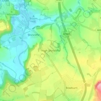
Naam: Topografische kaart High Shincliffe, hoogte, reliëf.

Locatie: High Shincliffe, Shincliffe, County Durham, North East, England, DH1 2UB, United Kingdom (54.73434 -1.55863 54.77434 -1.51863)

Gemiddelde hoogte: 77 m

Minimale hoogte: 32 m

Maximale hoogte: 162 m

Andere topografische kaarten

Klik op een kaart om zijn topografie, zijn hoogte en zijn reliëf te bekijken.

City of Durham

United Kingdom > England > County Durham > Durham

Gemiddelde hoogte: 76 m

Consett

United Kingdom > England > County Durham

Gemiddelde hoogte: 205 m

Cornsay

United Kingdom > England > County Durham

Gemiddelde hoogte: 223 m

Gainford

United Kingdom > England > County Durham

Gemiddelde hoogte: 100 m

Belmont

United Kingdom > England > County Durham > Carrville

Gemiddelde hoogte: 76 m

Bearpark

United Kingdom > England > County Durham > Bearpark

Gemiddelde hoogte: 106 m

Holwick

United Kingdom > England > County Durham

Gemiddelde hoogte: 413 m

Stanley

United Kingdom > England > County Durham

Gemiddelde hoogte: 176 m

Haswell

United Kingdom > England > County Durham

Gemiddelde hoogte: 132 m

Spennymoor

United Kingdom > England > County Durham

Gemiddelde hoogte: 117 m

Tyne and Wear

United Kingdom > England > County Durham

Gemiddelde hoogte: 82 m

Rokeby

United Kingdom > England > County Durham

Gemiddelde hoogte: 164 m

Hutton Henry

United Kingdom > England > County Durham

Gemiddelde hoogte: 121 m

Horden

United Kingdom > England > County Durham

Gemiddelde hoogte: 57 m

Wheatley Hill

United Kingdom > England > County Durham

Gemiddelde hoogte: 142 m

Tow Law

United Kingdom > England > County Durham

Gemiddelde hoogte: 280 m

Grey College

United Kingdom > England > County Durham > Durham > Houghall

Gemiddelde hoogte: 68 m

Muggleswick

United Kingdom > England > County Durham

Gemiddelde hoogte: 312 m

Consett

United Kingdom > England > County Durham

Gemiddelde hoogte: 205 m

Fishburn

United Kingdom > England > County Durham

Gemiddelde hoogte: 117 m

Haswell

United Kingdom > England > County Durham

Gemiddelde hoogte: 132 m

Winston

United Kingdom > England > County Durham

Gemiddelde hoogte: 120 m

Esh

United Kingdom > England > County Durham

Gemiddelde hoogte: 150 m

Newbiggin

United Kingdom > England > County Durham

Gemiddelde hoogte: 451 m

Urpeth

United Kingdom > England > County Durham

Gemiddelde hoogte: 69 m

Healeyfield

United Kingdom > England > County Durham > Castleside

Gemiddelde hoogte: 242 m

Stanley

United Kingdom > England > County Durham

Gemiddelde hoogte: 176 m

Thornley

United Kingdom > England > County Durham

Gemiddelde hoogte: 148 m

Lunedale

United Kingdom > England > County Durham

Gemiddelde hoogte: 446 m

Barnard Castle

United Kingdom > England > County Durham

Gemiddelde hoogte: 172 m

Horden

United Kingdom > England > County Durham

Gemiddelde hoogte: 57 m

Chilton

United Kingdom > England > County Durham > Chilton

Gemiddelde hoogte: 112 m

Tow Law

United Kingdom > England > County Durham

Gemiddelde hoogte: 280 m

Hunstanworth

United Kingdom > England > County Durham

Gemiddelde hoogte: 397 m

Woodland

United Kingdom > England > County Durham

Gemiddelde hoogte: 289 m

Shadforth

United Kingdom > England > County Durham

Gemiddelde hoogte: 126 m

Satley

United Kingdom > England > County Durham

Gemiddelde hoogte: 251 m

Cockfield

United Kingdom > England > County Durham

Gemiddelde hoogte: 191 m

Hawthorn

United Kingdom > England > County Durham

Gemiddelde hoogte: 85 m

River Skerne

United Kingdom > England > County Durham

Gemiddelde hoogte: 81 m

Mordon

United Kingdom > England > County Durham

Gemiddelde hoogte: 80 m

Dalton-le-Dale

United Kingdom > England > County Durham

Gemiddelde hoogte: 92 m

Murton

United Kingdom > England > County Durham

Gemiddelde hoogte: 114 m

Fishburn

United Kingdom > England > County Durham

Gemiddelde hoogte: 117 m

Boldron

United Kingdom > England > County Durham

Gemiddelde hoogte: 219 m

Scargill

United Kingdom > England > County Durham

Gemiddelde hoogte: 299 m

Crook

United Kingdom > England > County Durham

Gemiddelde hoogte: 177 m

Bowes

United Kingdom > England > County Durham

Gemiddelde hoogte: 351 m

Burnhope

United Kingdom > England > County Durham

Gemiddelde hoogte: 194 m

River Wear

United Kingdom > England > County Durham

Gemiddelde hoogte: 148 m

Peterlee

United Kingdom > England > County Durham

Gemiddelde hoogte: 92 m

Witton-le-Wear

United Kingdom > England > County Durham

Gemiddelde hoogte: 133 m

Pittington

United Kingdom > England > County Durham

Gemiddelde hoogte: 101 m

South Pelaw

United Kingdom > England > County Durham

Gemiddelde hoogte: 44 m

Bowes

United Kingdom > England > County Durham

Gemiddelde hoogte: 351 m

Shildon

United Kingdom > England > County Durham

Gemiddelde hoogte: 135 m

Edmondsley

United Kingdom > England > County Durham

Gemiddelde hoogte: 112 m

South Hetton

United Kingdom > England > County Durham

Gemiddelde hoogte: 126 m

Eggleston

United Kingdom > England > County Durham

Gemiddelde hoogte: 359 m

Castle Eden

United Kingdom > England > County Durham

Gemiddelde hoogte: 112 m

Spennymoor

United Kingdom > England > County Durham

Gemiddelde hoogte: 115 m

Tow Law

United Kingdom > England > County Durham

Gemiddelde hoogte: 279 m

Bishop Auckland

United Kingdom > England > County Durham

Gemiddelde hoogte: 109 m

Sacriston

United Kingdom > England > County Durham

Gemiddelde hoogte: 133 m

Mickleton

United Kingdom > England > County Durham

Gemiddelde hoogte: 350 m

Cornforth

United Kingdom > England > County Durham

Gemiddelde hoogte: 110 m

Thornley

United Kingdom > England > County Durham

Gemiddelde hoogte: 148 m

Langton

United Kingdom > England > County Durham

Gemiddelde hoogte: 105 m

Wingate

United Kingdom > England > County Durham

Gemiddelde hoogte: 128 m

Tyne and Wear

United Kingdom > England > County Durham

Gemiddelde hoogte: 82 m

Barnard Castle

United Kingdom > England > County Durham

Gemiddelde hoogte: 170 m

Trimdon

United Kingdom > England > County Durham

Gemiddelde hoogte: 133 m

Coxhoe

United Kingdom > England > County Durham

Gemiddelde hoogte: 111 m

Staindrop

United Kingdom > England > County Durham

Gemiddelde hoogte: 158 m

Sedgefield

United Kingdom > England > County Durham

Gemiddelde hoogte: 90 m

Lanchester

United Kingdom > England > County Durham

Gemiddelde hoogte: 198 m

Startforth

United Kingdom > England > County Durham

Gemiddelde hoogte: 197 m

Seaham

United Kingdom > England > County Durham

Gemiddelde hoogte: 31 m

Wolsingham

United Kingdom > England > County Durham

Gemiddelde hoogte: 274 m

Cotherstone

United Kingdom > England > County Durham

Gemiddelde hoogte: 271 m

Brignall

United Kingdom > England > County Durham

Gemiddelde hoogte: 193 m

Bearpark

United Kingdom > England > County Durham

Gemiddelde hoogte: 106 m

West Auckland

United Kingdom > England > County Durham

Gemiddelde hoogte: 124 m

Hamsterley

United Kingdom > England > County Durham

Gemiddelde hoogte: 188 m

Wheatley Hill

United Kingdom > England > County Durham

Gemiddelde hoogte: 142 m

Rust jezelf uit voor je volgende avontuur:

🧴Tekenpincetten - Veilig teken verwijderen na een boswandeling
🧭Kaartlezen Boeken - Leer navigeren met kaart en kompas
🧦Thermosokken - Warme sokken voor koude wandelomstandigheden
📦Drybags - Waterdichte zakken voor bescherming van spullen
Lichtgewicht Tenten - Compacte tenten voor backpacken en kamperen

Als Amazon-partner verdient deze site een commissie op in aanmerking komende aankopen, zonder extra kosten voor jou.