
Topografische kaart Checotah
Interactieve kaart
Klik op de kaart om de hoogte weer te geven.
Checotah
Checotah is located at an elevation of 652 feet (199 m) at the intersection of I-40 and U.S. Route 69. Nearby is Eufaula Lake, the largest-capacity lake wholly within the state of Oklahoma.
Over deze kaart
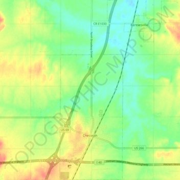
Naam: Topografische kaart Checotah, hoogte, reliëf.
Locatie: Checotah, McIntosh County, Oklahoma, 74426, United States (35.44943 -95.54899 35.53302 -95.50439)
Gemiddelde hoogte: 189 m
Minimale hoogte: 168 m
Maximale hoogte: 216 m
Andere topografische kaarten
Klik op een kaart om zijn topografie, zijn hoogte en zijn reliëf te bekijken.
Honey Springs Battlefield
United States > Oklahoma > McIntosh County > Rentiesville
Gemiddelde hoogte: 185 m