
Topografische kaart Burnsville
Interactieve kaart
Klik op de kaart om de hoogte weer te geven.
Over deze kaart
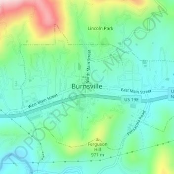
Naam: Topografische kaart Burnsville, hoogte, reliëf.
Locatie: Burnsville, Yancey County, North Carolina, United States (35.90734 -82.31252 35.92691 -82.28004)
Gemiddelde hoogte: 882 m
Minimale hoogte: 789 m
Maximale hoogte: 1.121 m
Andere topografische kaarten
Klik op een kaart om zijn topografie, zijn hoogte en zijn reliëf te bekijken.
Appalachian Mountains
United States > North Carolina > Yancey County
Appalachian Mountains, Yancey County, North Carolina, United States
Gemiddelde hoogte: 1.463 m
Mount Mitchell
United States > North Carolina > Yancey County
Mount Mitchell, Yancey County, North Carolina, United States
Gemiddelde hoogte: 1.743 m
Mitchell Ridge
United States > North Carolina > Yancey County
Mitchell Ridge, Yancey County, North Carolina, United States
Gemiddelde hoogte: 1.517 m
Cane River
United States > North Carolina > Yancey County > Low Gap
Cane River, Low Gap, Yancey County, North Carolina, 28714, United States
Gemiddelde hoogte: 944 m
Cane River
United States > North Carolina > Yancey County > Eskota
Cane River, Eskota, Yancey County, North Carolina, United States
Gemiddelde hoogte: 1.154 m
Lost Cove
United States > North Carolina > Yancey County > Lost Cove
Lost Cove, Yancey County, North Carolina, United States
Gemiddelde hoogte: 852 m