
Topografische kaart Mount Mitchell
Interactieve kaart
Klik op de kaart om de hoogte weer te geven.
Over deze kaart
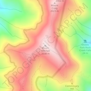
Naam: Topografische kaart Mount Mitchell, hoogte, reliëf.
Locatie: Mount Mitchell, Yancey County, North Carolina, United States (35.76491 -82.26517 35.76501 -82.26507)
Gemiddelde hoogte: 1.743 m
Minimale hoogte: 1.355 m
Maximale hoogte: 2.019 m
Mount Mitchell, known in Cherokee as Attakulla, is the highest peak of the Appalachian Mountains and the highest peak in mainland eastern North America. It is located near Burnsville in Yancey County, North Carolina in the Black Mountain subrange of the Appalachians about 19 miles (31 km) northeast of Asheville. It is protected by Mount Mitchell State Park and surrounded by the Pisgah National Forest. Mount Mitchell's elevation is 6,684 feet (2,037 m) above sea level.
Andere topografische kaarten
Klik op een kaart om zijn topografie, zijn hoogte en zijn reliëf te bekijken.
Appalachian Mountains
United States > North Carolina > Yancey County
Appalachian Mountains, Yancey County, North Carolina, United States
Gemiddelde hoogte: 1.463 m
Burnsville
United States > North Carolina > Yancey County
Burnsville, Yancey County, North Carolina, United States
Gemiddelde hoogte: 882 m
Mitchell Ridge
United States > North Carolina > Yancey County
Mitchell Ridge, Yancey County, North Carolina, United States
Gemiddelde hoogte: 1.517 m
Cane River
United States > North Carolina > Yancey County > Low Gap
Cane River, Low Gap, Yancey County, North Carolina, 28714, United States
Gemiddelde hoogte: 944 m
Cane River
United States > North Carolina > Yancey County > Eskota
Cane River, Eskota, Yancey County, North Carolina, United States
Gemiddelde hoogte: 1.154 m
Lost Cove
United States > North Carolina > Yancey County > Lost Cove
Lost Cove, Yancey County, North Carolina, United States
Gemiddelde hoogte: 852 m