
Topografische kaart Granite County
Interactieve kaart
Klik op de kaart om de hoogte weer te geven.
Over deze kaart
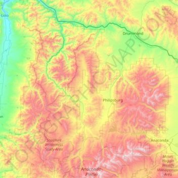
Naam: Topografische kaart Granite County, hoogte, reliëf.
Locatie: Granite County, Montana, United States (45.93863 -113.87836 46.83380 -113.03153)
Gemiddelde hoogte: 1.800 m
Minimale hoogte: 951 m
Maximale hoogte: 3.216 m
Andere topografische kaarten
Klik op een kaart om zijn topografie, zijn hoogte en zijn reliëf te bekijken.
Garnet
United States > Montana > Granite County
Garnet, Granite County, Montana, United States
Gemiddelde hoogte: 1.758 m
Buffalo
United States > Montana > Fergus County
Buffalo, Fergus County, Montana, 59418, United States
Gemiddelde hoogte: 1.320 m
Augusta
United States > Montana > Lewis and Clark County > Augusta
Augusta, Lewis and Clark County, Montana, 59410, United States
Gemiddelde hoogte: 1.246 m
Helena
United States > Montana > Lewis and Clark County
Helena, Lewis and Clark County, Montana, United States
Gemiddelde hoogte: 1.296 m
Nelson
United States > Montana > Lewis and Clark County
Nelson, Lewis and Clark County, Montana, United States
Gemiddelde hoogte: 1.377 m
Wyola
United States > Montana > Big Horn County
Wyola, Big Horn County, Montana, United States
Gemiddelde hoogte: 1.176 m
Cooper
United States > Montana > Cascade County
Cooper, Cascade County, Montana, United States
Gemiddelde hoogte: 1.035 m
Barker
United States > Montana > Broadwater County
Barker, Broadwater County, Montana, United States
Gemiddelde hoogte: 1.292 m
Lewis and Clark County
Lewis and Clark County, Montana, United States
Gemiddelde hoogte: 1.554 m
Tunnel Creek
United States > Montana > Flathead County
Tunnel Creek, Flathead County, Montana, United States
Gemiddelde hoogte: 1.211 m
Bozeman
United States > Montana > Gallatin County
Bozeman, Gallatin County, Montana, United States
Gemiddelde hoogte: 1.495 m
Lake McDonald
United States > Montana > Flathead County
Lake McDonald, Flathead County, Montana, United States
Gemiddelde hoogte: 1.209 m
Kalispell
United States > Montana > Flathead County
Kalispell, Flathead County, Montana, United States
Gemiddelde hoogte: 934 m
Basin
United States > Montana > Jefferson County
Basin, Jefferson County, Montana, 59631, United States
Gemiddelde hoogte: 1.892 m
Yellowstone River
United States > Montana > Custer County
Yellowstone River, Custer County, Montana, 59301, United States
Gemiddelde hoogte: 720 m
Mount Cecelia
United States > Montana > Cascade County
Mount Cecelia, Cascade County, Montana, United States
Gemiddelde hoogte: 1.527 m
Aubery Lake
United States > Montana > Glacier County
Aubery Lake, Glacier County, Montana, United States
Gemiddelde hoogte: 1.307 m
Sunrise Trailer Court
United States > Montana > Pondera County > Conrad
Sunrise Trailer Court, Conrad, Pondera County, Montana, United States
Gemiddelde hoogte: 1.071 m
Pinegrove
United States > Montana > Missoula County > Pinegrove
Pinegrove, Missoula County, Montana, 59851, United States
Gemiddelde hoogte: 1.155 m
West Branch Daily Creek
United States > Montana > Powder River County
West Branch Daily Creek, Powder River County, Montana, United States
Gemiddelde hoogte: 1.066 m
Mill Point
United States > Montana > Ravalli County
Mill Point, Ravalli County, Montana, United States
Gemiddelde hoogte: 2.129 m
Red Lodge
United States > Montana > Carbon County > Red Lodge
Red Lodge, Carbon County, Montana, United States
Gemiddelde hoogte: 1.720 m
Great Canyon
United States > Montana > Stillwater County
Great Canyon, Stillwater County, Montana, United States
Gemiddelde hoogte: 1.200 m
Mount Fox
United States > Montana > Park County
Mount Fox, Park County, Montana, United States
Gemiddelde hoogte: 3.129 m
Bozeman
United States > Montana > Gallatin County > Bozeman
Bozeman, Gallatin County, Montana, 59715, United States
Gemiddelde hoogte: 1.679 m
Laurel
United States > Montana > Yellowstone County > Laurel
Laurel, Yellowstone County, Montana, 59044, United States
Gemiddelde hoogte: 1.025 m
Prospect Creek
United States > Montana > Sanders County
Prospect Creek, Sanders County, Montana, 59873, United States
Gemiddelde hoogte: 1.070 m
Herron
United States > Montana > Hill County > Herron
Herron, Hill County, Montana, United States
Gemiddelde hoogte: 790 m
Mount Wallace
United States > Montana > Park County
Mount Wallace, Park County, Montana, United States
Gemiddelde hoogte: 2.845 m
Flagstaff Hill
United States > Montana > Hill County
Flagstaff Hill, Hill County, Montana, United States
Gemiddelde hoogte: 881 m
Mount May
Mount May, Flathead County, Montana, United States
Gemiddelde hoogte: 1.869 m
Yellowstone County
Yellowstone County, Montana, United States
Gemiddelde hoogte: 1.067 m
Cotter Dam
United States > Montana > Chouteau County
Cotter Dam, Chouteau County, Montana, United States
Gemiddelde hoogte: 945 m
Porcupine Ridge
United States > Montana > Glacier County
Porcupine Ridge, Glacier County, Montana, United States
Gemiddelde hoogte: 1.966 m
Busby
United States > Montana > Big Horn County
Busby, Busby District, Big Horn County, Montana, 59016, United States
Gemiddelde hoogte: 1.090 m
Billings
United States > Montana > Yellowstone County
Billings, Yellowstone County, Montana, United States
Gemiddelde hoogte: 1.023 m
Musselshell County
Musselshell County, Montana, United States
Gemiddelde hoogte: 1.086 m
Glengarry
United States > Montana > Glengarry
Glengarry, Fergus County, Montana, United States
Gemiddelde hoogte: 1.257 m
Silver Bow County
Silver Bow County, Montana, United States
Gemiddelde hoogte: 1.987 m
Saint Mary Peak
Saint Mary Peak, Ravalli County, Montana, United States
Gemiddelde hoogte: 2.468 m
Merino
United States > Montana > Merino
Merino, Judith Basin County, Montana, United States
Gemiddelde hoogte: 1.291 m
West Glacier
United States > Montana > Flathead County > West Glacier
West Glacier, Flathead County, Montana, 59936, United States
Gemiddelde hoogte: 1.201 m
Missoula
United States > Montana > Missoula County
Missoula, Missoula County, Montana, United States
Gemiddelde hoogte: 1.173 m
Gallatin County
Gallatin County, Montana, United States
Gemiddelde hoogte: 2.058 m
Mount Helena
United States > Montana > Lewis and Clark County > Helena
Mount Helena, Helena, Lewis and Clark County, Montana, 59601, United States
Gemiddelde hoogte: 1.388 m
Bald Hills
United States > Montana > Meagher County
Bald Hills, Meagher County, Montana, United States
Gemiddelde hoogte: 1.735 m
Glacier County
Glacier County, Montana, United States
Gemiddelde hoogte: 1.416 m