
Topografische kaart Willcox
Interactieve kaart
Klik op de kaart om de hoogte weer te geven.
Over deze kaart
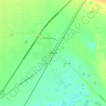
Naam: Topografische kaart Willcox, hoogte, reliëf.
Locatie: Willcox, Cochise County, Arizona, 85643, United States (32.21291 -109.87158 32.29291 -109.79158)
Gemiddelde hoogte: 1.274 m
Minimale hoogte: 1.263 m
Maximale hoogte: 1.290 m
Willcox's high elevation gives it a milder climate than the nearby Valley of the Sun and Sonoran Desert. It also receives more rainfall than Tucson and Phoenix due to the summer monsoon rains and thus it has a hot semi-arid climate (Koppen: BSh).
Andere topografische kaarten
Klik op een kaart om zijn topografie, zijn hoogte en zijn reliëf te bekijken.
Chiricahua National Monument
United States > Arizona > Cochise County
Chiricahua National Monument, Cochise County, Arizona, United States
Gemiddelde hoogte: 1.861 m
Bakerville
United States > Arizona > Cochise County > Bisbee > Warren
Bakerville, Warren, Bisbee, Cochise County, Arizona, 85603, United States
Gemiddelde hoogte: 1.579 m
Cathedral Rock
United States > Arizona > Cochise County
Cathedral Rock, Cochise County, Arizona, United States
Gemiddelde hoogte: 1.774 m
Douglas
United States > Arizona > Cochise County > Douglas
Douglas, Cochise County, Arizona, United States
Gemiddelde hoogte: 1.265 m
Sierra Vista
United States > Arizona > Cochise County
Sierra Vista, Cochise County, Arizona, United States
Gemiddelde hoogte: 1.507 m
Portal
United States > Arizona > Cochise County > Portal
Portal, Cochise County, Arizona, United States
Gemiddelde hoogte: 1.523 m
Bisbee
United States > Arizona > Cochise County
Bisbee, Cochise County, Arizona, United States
Gemiddelde hoogte: 1.676 m
Whetstone
United States > Arizona > Cochise County
Whetstone, Cochise County, Arizona, United States
Gemiddelde hoogte: 1.324 m