
Topografische kaart Sedibeng District Municipality
Interactieve kaart
Klik op de kaart om de hoogte weer te geven.
Over deze kaart
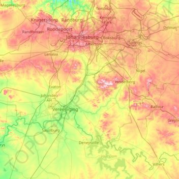
Naam: Topografische kaart Sedibeng District Municipality, hoogte, reliëf.
Locatie: Sedibeng District Municipality, Gauteng, South Africa (-26.92383 27.56909 -26.17224 28.86129)
Gemiddelde hoogte: 1.554 m
Minimale hoogte: 1.346 m
Maximale hoogte: 1.902 m
Andere topografische kaarten
Klik op een kaart om zijn topografie, zijn hoogte en zijn reliëf te bekijken.
City of Tshwane Metropolitan Municipality
City of Tshwane Metropolitan Municipality, Gauteng, South Africa
Gemiddelde hoogte: 1.288 m
Randburg
South Africa > Gauteng > City of Johannesburg Metropolitan Municipality
Randburg, City of Johannesburg Metropolitan Municipality, Gauteng, 2125, South Africa
Gemiddelde hoogte: 1.569 m
Westonaria Local Municipality
South Africa > Gauteng > West Rand District Municipality
Westonaria Local Municipality, West Rand District Municipality, Gauteng, South Africa
Gemiddelde hoogte: 1.564 m
Lesedi Local Municipality
South Africa > Gauteng > Sedibeng District Municipality
Lesedi Local Municipality, Sedibeng District Municipality, Gauteng, 1441, South Africa
Gemiddelde hoogte: 1.613 m
Pienaars
South Africa > Gauteng > City of Tshwane Metropolitan Municipality > De Rust Caravan Park
Pienaars, De Rust Caravan Park, City of Tshwane Metropolitan Municipality, Gauteng, 0407, South Africa
Gemiddelde hoogte: 1.093 m
Vereeniging
South Africa > Gauteng > Sedibeng District Municipality > Vereeniging
Vereeniging, Emfuleni Local Municipality, Sedibeng District Municipality, Gauteng, 1939, South Africa
Gemiddelde hoogte: 1.475 m
City of Ekurhuleni Metropolitan Municipality
City of Ekurhuleni Metropolitan Municipality, Gauteng, South Africa
Gemiddelde hoogte: 1.588 m
Benoni
South Africa > Gauteng > City of Ekurhuleni Metropolitan Municipality
Benoni, City of Ekurhuleni Metropolitan Municipality, Gauteng, 1500, South Africa
Gemiddelde hoogte: 1.645 m