
Topografische kaart Stephens County
Interactieve kaart
Klik op de kaart om de hoogte weer te geven.
Over deze kaart
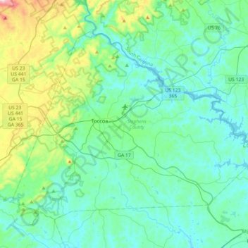
Naam: Topografische kaart Stephens County, hoogte, reliëf.
Locatie: Stephens County, Georgia, United States (34.46030 -83.45979 34.68720 -83.10331)
Gemiddelde hoogte: 299 m
Minimale hoogte: 197 m
Maximale hoogte: 777 m
According to the U.S. Census Bureau, the county has a total area of 184 square miles (480 km2), of which 179 square miles (460 km2) is land and 5.1 square miles (13 km2) (2.8%) is water. The county is located mainly within the upper Piedmont region of the state, with western portions of the county having the highest elevations and located in the foothills of the Blue Ridge Mountains.
Andere topografische kaarten
Klik op een kaart om zijn topografie, zijn hoogte en zijn reliëf te bekijken.
Cumming
United States > Georgia > Forsyth County
Cumming, Forsyth County, Georgia, United States
Gemiddelde hoogte: 365 m
Marietta
United States > Georgia > Cobb County
Marietta, Cobb County, Georgia, United States
Gemiddelde hoogte: 323 m
Leesburg
United States > Georgia > Lee County
Leesburg, Lee County, Georgia, United States
Gemiddelde hoogte: 76 m
Hoschton
United States > Georgia > Jackson County
Hoschton, Jackson County, Georgia, United States
Gemiddelde hoogte: 263 m
Roswell
United States > Georgia > Fulton County
Roswell, Fulton County, Georgia, United States
Gemiddelde hoogte: 316 m
Union City
United States > Georgia > Fulton County
Union City, Fulton County, Georgia, United States
Gemiddelde hoogte: 284 m
Treutlen County
Treutlen County, Georgia, 30457, United States
Gemiddelde hoogte: 75 m
Chattahoochee County
United States > Georgia > Chattahoochee County
Chattahoochee County, Georgia, United States
Gemiddelde hoogte: 123 m
Norman Park
United States > Georgia > Colquitt County
Norman Park, Colquitt County, Georgia, United States
Gemiddelde hoogte: 100 m
Augusta Canal
United States > Georgia > Richmond County > Augusta
Augusta Canal, Augusta, Richmond County, Georgia, United States
Gemiddelde hoogte: 80 m
Ben Hill County
Ben Hill County, Georgia, 31750, United States
Gemiddelde hoogte: 88 m
Jasper
United States > Georgia > Pickens County
Jasper, Pickens County, Georgia, 30142, United States
Gemiddelde hoogte: 408 m
Brunswick
United States > Georgia > Glynn County
Brunswick, Glynn County, Georgia, United States
Gemiddelde hoogte: 2 m
Norwood
United States > Georgia > Warren County
Norwood, Warren County, Georgia, United States
Gemiddelde hoogte: 180 m
Kentucky Island
United States > Georgia > Wayne County
Kentucky Island, Wayne County, Georgia, United States
Gemiddelde hoogte: 19 m
Chatsworth
United States > Georgia > Murray County
Chatsworth, Murray County, Georgia, United States
Gemiddelde hoogte: 241 m
Aboretum
United States > Georgia > Cobb County
Aboretum, Cobb County, Georgia, United States
Gemiddelde hoogte: 319 m
Shake Rag
United States > Georgia > Fulton County > Johns Creek
Shake Rag, Johns Creek, Fulton County, Georgia, 30095, United States
Gemiddelde hoogte: 300 m
Colony South
United States > Georgia > Hall County
Colony South, Hall County, Georgia, United States
Gemiddelde hoogte: 328 m
Huntington Place
United States > Georgia > Fayette County > Peachtree City
Huntington Place, Peachtree City, Fayette County, Georgia, 30269, United States
Gemiddelde hoogte: 249 m
Dorchester
United States > Georgia > Richmond County > Augusta
Dorchester, Augusta, Richmond County, Georgia, 30909, United States
Gemiddelde hoogte: 90 m
Emerson Park
United States > Georgia > Ware County
Emerson Park, Ware County, Georgia, 31503, United States
Gemiddelde hoogte: 44 m
Bamburg
United States > Georgia > Echols County
Bamburg, Echols County, Georgia, United States
Gemiddelde hoogte: 48 m
Haralson County
Haralson County, Georgia, United States
Gemiddelde hoogte: 353 m
Bamboo Forest
United States > Georgia > Fulton County > Sandy Springs
Bamboo Forest, Sandy Springs, Fulton County, Georgia, 30339, United States
Gemiddelde hoogte: 278 m
Chapel Hill
United States > Georgia > Douglas County
Chapel Hill, Douglas County, Georgia, 30135, United States
Gemiddelde hoogte: 296 m
Winston
United States > Georgia > Douglas County
Winston, Douglas County, Georgia, 30187, United States
Gemiddelde hoogte: 340 m
Buford
United States > Georgia > Gwinnett County
Buford, Gwinnett County, Georgia, United States
Gemiddelde hoogte: 340 m
Holmesville
United States > Georgia > Appling County
Holmesville, Appling County, Georgia, United States
Gemiddelde hoogte: 55 m
Juno
United States > Georgia > Dawson County
Juno, Dawson County, Georgia, United States
Gemiddelde hoogte: 454 m
Tyree
United States > Georgia > Douglas County
Tyree, Douglas County, Georgia, United States
Gemiddelde hoogte: 346 m
Velta
United States > Georgia > Rockdale County
Velta, Rockdale County, Georgia, 30094, United States
Gemiddelde hoogte: 235 m
Effingham County
Effingham County, Georgia, United States
Gemiddelde hoogte: 21 m
White Cliffs
United States > Georgia > Gilmer County
White Cliffs, Gilmer County, Georgia, United States
Gemiddelde hoogte: 833 m
Emerson
United States > Georgia > Bartow County
Emerson, Bartow County, Georgia, 30137, United States
Gemiddelde hoogte: 254 m
Ball Ground
United States > Georgia > Cherokee County
Ball Ground, Cherokee County, Georgia, United States
Gemiddelde hoogte: 331 m
Commerce
United States > Georgia > Jackson County
Commerce, Jackson County, Georgia, United States
Gemiddelde hoogte: 252 m
Washington County
Washington County, Georgia, United States
Gemiddelde hoogte: 113 m