
Topografische kaart Churchill Butte
Interactieve kaart
Klik op de kaart om de hoogte weer te geven.
Over deze kaart
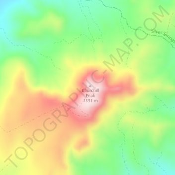
Naam: Topografische kaart Churchill Butte, hoogte, reliëf.
Locatie: Churchill Butte, Lyon County, Nevada, 89429, United States (39.33931 -119.29605 39.33941 -119.29595)
Gemiddelde hoogte: 1.645 m
Minimale hoogte: 1.484 m
Maximale hoogte: 1.836 m
Andere topografische kaarten
Klik op een kaart om zijn topografie, zijn hoogte en zijn reliëf te bekijken.
Mound House
United States > Nevada > Lyon County
Mound House, Lyon County, Nevada, United States
Gemiddelde hoogte: 1.521 m
Fernley
United States > Nevada > Lyon County
Fernley, Lyon County, Nevada, United States
Gemiddelde hoogte: 1.447 m
Yerington
United States > Nevada > Lyon County
Yerington, Lyon County, Nevada, 89447, United States
Gemiddelde hoogte: 1.358 m
Dayton
United States > Nevada > Lyon County
Dayton, Lyon County, Nevada, 89403, United States
Gemiddelde hoogte: 1.530 m
Carson Rapids City
United States > Nevada > Lyon County > Dayton
Carson Rapids City, Dayton, Lyon County, Nevada, United States
Gemiddelde hoogte: 1.394 m
Wellington
United States > Nevada > Lyon County
Wellington, Lyon County, Nevada, 89444, United States
Gemiddelde hoogte: 1.523 m
Silver Springs
United States > Nevada > Lyon County
Silver Springs, Lyon County, Nevada, 89429, United States
Gemiddelde hoogte: 1.366 m