
Topografische kaart Mound House
Interactieve kaart
Klik op de kaart om de hoogte weer te geven.
Over deze kaart
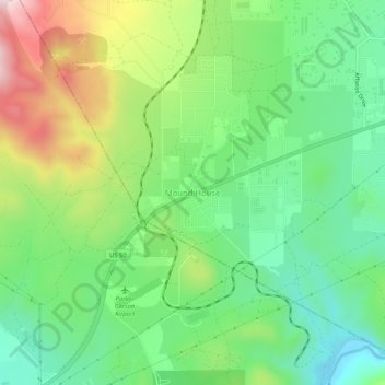
Naam: Topografische kaart Mound House, hoogte, reliëf.
Locatie: Mound House, Lyon County, Nevada, United States (39.19224 -119.69581 39.23224 -119.65581)
Gemiddelde hoogte: 1.521 m
Minimale hoogte: 1.359 m
Maximale hoogte: 1.810 m
Mound House is a small unincorporated community in Lyon County, Nevada on U.S. Route 50 that is situated between Nevada's capital, Carson City, and Dayton. Its elevation is 4,974 feet (1,516 m). It is in Lyon County, one of eight Nevada counties that allow for legalized prostitution, and is home to four brothels.
Andere topografische kaarten
Klik op een kaart om zijn topografie, zijn hoogte en zijn reliëf te bekijken.
Fernley
United States > Nevada > Lyon County
Fernley, Lyon County, Nevada, United States
Gemiddelde hoogte: 1.447 m
Yerington
United States > Nevada > Lyon County
Yerington, Lyon County, Nevada, 89447, United States
Gemiddelde hoogte: 1.358 m
Churchill Butte
United States > Nevada > Lyon County
Churchill Butte, Lyon County, Nevada, 89429, United States
Gemiddelde hoogte: 1.645 m
Carson Rapids City
United States > Nevada > Lyon County > Dayton
Carson Rapids City, Dayton, Lyon County, Nevada, United States
Gemiddelde hoogte: 1.394 m
Dayton
United States > Nevada > Lyon County
Dayton, Lyon County, Nevada, 89403, United States
Gemiddelde hoogte: 1.530 m
Wellington
United States > Nevada > Lyon County
Wellington, Lyon County, Nevada, 89444, United States
Gemiddelde hoogte: 1.523 m
Silver Springs
United States > Nevada > Lyon County
Silver Springs, Lyon County, Nevada, 89429, United States
Gemiddelde hoogte: 1.366 m