
Topografische kaart Reefton
Interactieve kaart
Klik op de kaart om de hoogte weer te geven.
Over deze kaart
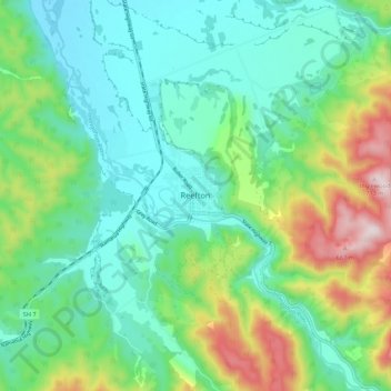
Naam: Topografische kaart Reefton, hoogte, reliëf.
Locatie: Reefton, Buller District, West Coast, 7830, New Zealand (-42.15594 171.82346 -42.07594 171.90346)
Gemiddelde hoogte: 310 m
Minimale hoogte: 156 m
Maximale hoogte: 713 m
Located in the Inangahua Valley at an altitude of 194m, Reefton falls under the Köppen-Geiger climate classification of Cfb (Oceanic). At an average temperature of 15.9 °C, February is the warmest month. July is the coldest month, at 6.8 °C. Reefton's average annual temperature is 11.4 °C. On average, snowfall occurs on 1.4 days annually, and an average of 22.1 days per year will exceed 26.7 °C (80 °F). During an average winter, Reefton can expect to see 47 days of frost.
Andere topografische kaarten
Klik op een kaart om zijn topografie, zijn hoogte en zijn reliëf te bekijken.
Mokihinui
New Zealand > West Coast > Buller District
Mokihinui, Buller District, West Coast, New Zealand
Gemiddelde hoogte: 55 m
Charleston
New Zealand > West Coast > Buller District
Charleston, Buller District, West Coast, New Zealand
Gemiddelde hoogte: 24 m
Granity
New Zealand > West Coast > Buller District
Granity, Buller District, West Coast, New Zealand
Gemiddelde hoogte: 150 m
Lewis Pass
New Zealand > West Coast > Buller District
Lewis Pass, Buller District, West Coast, New Zealand
Gemiddelde hoogte: 1.039 m
Cape Foulwind
New Zealand > West Coast > Buller District > Cape Foulwind
Cape Foulwind, Buller District, West Coast, New Zealand
Gemiddelde hoogte: 14 m
Hukarere
New Zealand > West Coast > Buller District
Hukarere, Buller District, West Coast, New Zealand
Gemiddelde hoogte: 131 m
Ikamatua
New Zealand > West Coast > Buller District
Ikamatua, Buller District, West Coast, New Zealand
Gemiddelde hoogte: 122 m
Westport
New Zealand > West Coast > Buller District
Westport, Buller District, West Coast, 7825, New Zealand
Gemiddelde hoogte: 13 m