
Topografische kaart Granity
Interactieve kaart
Klik op de kaart om de hoogte weer te geven.
Over deze kaart
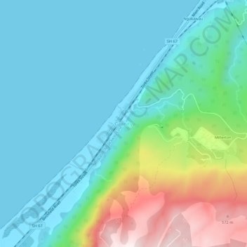
Naam: Topografische kaart Granity, hoogte, reliëf.
Locatie: Granity, Buller District, West Coast, New Zealand (-41.65017 171.83495 -41.61017 171.87495)
Gemiddelde hoogte: 150 m
Minimale hoogte: 0 m
Maximale hoogte: 638 m
Andere topografische kaarten
Klik op een kaart om zijn topografie, zijn hoogte en zijn reliëf te bekijken.
Charleston
New Zealand > West Coast > Buller District
Charleston, Buller District, West Coast, New Zealand
Gemiddelde hoogte: 24 m
Mokihinui
New Zealand > West Coast > Buller District
Mokihinui, Buller District, West Coast, New Zealand
Gemiddelde hoogte: 55 m
Lewis Pass
New Zealand > West Coast > Buller District
Lewis Pass, Buller District, West Coast, New Zealand
Gemiddelde hoogte: 1.039 m
Cape Foulwind
New Zealand > West Coast > Buller District > Cape Foulwind
Cape Foulwind, Buller District, West Coast, New Zealand
Gemiddelde hoogte: 14 m
Hukarere
New Zealand > West Coast > Buller District
Hukarere, Buller District, West Coast, New Zealand
Gemiddelde hoogte: 131 m
Ikamatua
New Zealand > West Coast > Buller District
Ikamatua, Buller District, West Coast, New Zealand
Gemiddelde hoogte: 122 m
Westport
New Zealand > West Coast > Buller District
Westport, Buller District, West Coast, 7825, New Zealand
Gemiddelde hoogte: 13 m
Reefton
New Zealand > West Coast > Buller District
Reefton, Buller District, West Coast, 7830, New Zealand
Gemiddelde hoogte: 310 m