
Topografische kaart Weekley
Klik op de kaart om de hoogte weer te geven.
Over deze kaart
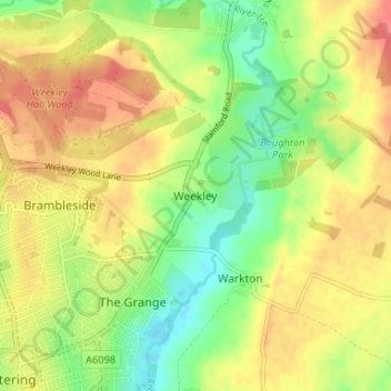
Naam: Topografische kaart Weekley, hoogte, reliëf.
Gemiddelde hoogte: 92 m
Minimale hoogte: 61 m
Maximale hoogte: 120 m
Andere topografische kaarten
Klik op een kaart om zijn topografie, zijn hoogte en zijn reliëf te bekijken.
Wellingborough
United Kingdom > England > North Northamptonshire > Great Doddington
Gemiddelde hoogte: 83 m
Irchester Country Park
United Kingdom > England > North Northamptonshire > Little Irchester
Gemiddelde hoogte: 60 m
River Nene Navigation
United Kingdom > England > North Northamptonshire > Irchester
Gemiddelde hoogte: 55 m
Finedon
United Kingdom > England > North Northamptonshire
The town of Finedon rises to approximately 90 metres Above Ordinance Datum from the River Ise, with the historical centre of the settlement occupying a shallow south-west facing valley. The contemporary point of maximum elevation in the parish is the summit of the disused Sidegate Lane Landfill Site, located…
Gemiddelde hoogte: 75 m
Irchester
United Kingdom > England > North Northamptonshire
The 12th-century English historian Henry of Huntingdon mentions a Roman "town on the river (Nene), in Huntingdonshire, which is entirely destroyed" as one of his interpretations of the 28 cities of Britain. The town is mentioned also by William Lambarde in Dictionarium Angliae Topographicum & Historicum.
Gemiddelde hoogte: 62 m
King's Cliffe
United Kingdom > England > North Northamptonshire > King's Cliffe
Gemiddelde hoogte: 69 m
Easton on the Hill
United Kingdom > England > North Northamptonshire > Easton on the Hill
Gemiddelde hoogte: 71 m
Barton Seagrave
United Kingdom > England > North Northamptonshire
Other natives of the village include topographer John Bridges and his brother, Charles, a painter.
Gemiddelde hoogte: 78 m
Irchester
United Kingdom > England > North Northamptonshire
The 12th-century English historian Henry of Huntingdon mentions a Roman "town on the river (Nene), in Huntingdonshire, which is entirely destroyed" as one of his interpretations of the 28 cities of Britain. The town is mentioned also by William Lambarde in Dictionarium Angliae Topographicum & Historicum.
Gemiddelde hoogte: 62 m