
Topografische kaart Irchester
Klik op de kaart om de hoogte weer te geven.
Irchester
The 12th-century English historian Henry of Huntingdon mentions a Roman "town on the river (Nene), in Huntingdonshire, which is entirely destroyed" as one of his interpretations of the 28 cities of Britain. The town is mentioned also by William Lambarde in Dictionarium Angliae Topographicum & Historicum.
Over deze kaart
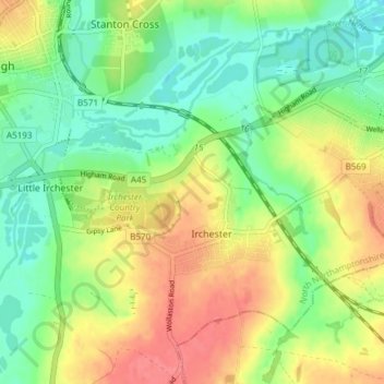
Naam: Topografische kaart Irchester, hoogte, reliëf.
Locatie: Irchester, North Northamptonshire, England, United Kingdom (52.26827 -0.68572 52.30521 -0.61055)
Gemiddelde hoogte: 62 m
Minimale hoogte: 32 m
Maximale hoogte: 98 m
Andere topografische kaarten
Klik op een kaart om zijn topografie, zijn hoogte en zijn reliëf te bekijken.
Irchester Country Park
United Kingdom > England > North Northamptonshire > Little Irchester
Gemiddelde hoogte: 60 m
River Nene Navigation
United Kingdom > England > North Northamptonshire > Irchester
Gemiddelde hoogte: 55 m