
Topografische kaart East Godavari
Interactieve kaart
Klik op de kaart om de hoogte weer te geven.
Over deze kaart
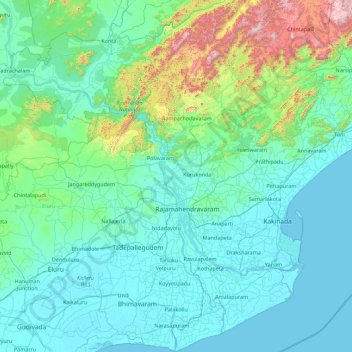
Naam: Topografische kaart East Godavari, hoogte, reliëf.
Locatie: East Godavari, Andhra Pradesh, India (16.31028 80.88549 18.01475 82.60489)
Gemiddelde hoogte: 161 m
Minimale hoogte: -4 m
Maximale hoogte: 1.472 m
East Godavari occupies an area of 12,805 square kilometres (4,944 sq mi), comparatively equivalent to Indonesia's Sumba Island. The district is bounded on north by Visakhapatnam District, Malkangiri District of Orissa on the northwest by Khammam District and Sukma district of Chhattisgarh, on the east and south by the Bay of Bengal and on the west by West Godavari. It has a coastline of 144 km (89 mi). The small enclave (30 km2 or 12 sq mi) of the Yanam district of Puducherry state lies within this district. The topography consists of hills in the north west and fertile plains in the central part and towards the east. The plains are drained by godavari river and its landscape is filled with evergreen paddy fields all along the delta. It is the largest producer of Paddy in whole of Andhra Pradesh. Papikondalu part of Eastern Ghats is the hilly terrain in located the north western part of this district, it consists of hills running on both the sides of river godavari till Bhadrachalam, Telangana. The temperature remains humid for most of the months as it is located in the coastal belt. This district is referred as the green belt of Andhra due to its greenery spread all around. There are abundant deciduous forests in the Northwest part near Maredumilli and to the east near Kakinada there are mangrove forests.
Andere topografische kaarten
Klik op een kaart om zijn topografie, zijn hoogte en zijn reliëf te bekijken.
Machilipatnam
India > Andhra Pradesh > Machilipatnam
Machilipatnam, Krishna, Andhra Pradesh, 521001, India
Gemiddelde hoogte: 4 m
Sullurpeta
India > Andhra Pradesh > Sullurpeta
Sullurpeta, Tirupati District, Andhra Pradesh, 524121, India
Gemiddelde hoogte: 4 m
Narsipatnam
Narsipatnam, Anakapalli, Andhra Pradesh, India
Gemiddelde hoogte: 92 m
Sarpavaram
India > Andhra Pradesh > Kakinada (Rural) > Sarpavaram
Sarpavaram, Kakinada (Rural), Kakinada, Andhra Pradesh, 533003, India
Gemiddelde hoogte: 6 m
Chennuru
India > Andhra Pradesh > Pedana > Chennuru
Chennuru, Pedana, Krishna, Andhra Pradesh, India
Gemiddelde hoogte: 4 m
Rajamahendravaram
India > Andhra Pradesh > Rajamahendravaram
Rajamahendravaram, Rajahmundry (Urban), East Godavari, Andhra Pradesh, 533100, India
Gemiddelde hoogte: 29 m
Nellore
India > Andhra Pradesh > Nellore
Nellore, Sri Potti Sriramulu Nellore, Andhra Pradesh, 524001, India
Gemiddelde hoogte: 17 m
Salamanda
India > Andhra Pradesh > Salamanda
Salamanda, Visakhapatnam, Andhra Pradesh, India
Gemiddelde hoogte: 1.131 m
Sriharikota
Sriharikota, Sullurpeta, Sri Potti Sriramulu Nellore, Andhra Pradesh, 524124, India
Gemiddelde hoogte: 2 m