
Topografische kaart Sławutowo
Interactieve kaart
Klik op de kaart om de hoogte weer te geven.
Over deze kaart
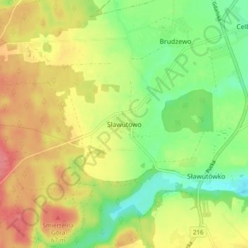
Naam: Topografische kaart Sławutowo, hoogte, reliëf.
Gemiddelde hoogte: 51 m
Minimale hoogte: 16 m
Maximale hoogte: 87 m
Andere topografische kaarten
Klik op een kaart om zijn topografie, zijn hoogte en zijn reliëf te bekijken.
Sławoszyno
Poland > Pomeranian Voivodeship > Puck County
Sławoszyno, gmina Krokowa, Puck County, Pomeranian Voivodeship, 84-110, Poland
Gemiddelde hoogte: 23 m
Władysławowo
Poland > Pomeranian Voivodeship > Puck County
Władysławowo, Puck County, Pomeranian Voivodeship, Poland
Gemiddelde hoogte: 11 m
Kartoszyno
Poland > Pomeranian Voivodeship > Puck County
Kartoszyno, gmina Krokowa, Puck County, Pomeranian Voivodeship, 84-110, Poland
Gemiddelde hoogte: 36 m
Żelistrzewo
Poland > Pomeranian Voivodeship > Puck County
Żelistrzewo, gmina Puck, Puck County, Pomeranian Voivodeship, 84-122, Poland
Gemiddelde hoogte: 25 m
Puck County
Poland > Pomeranian Voivodeship > Puck County
Puck County, Pomeranian Voivodeship, Poland
Gemiddelde hoogte: 44 m