
Topografische kaart Władysławowo
Interactieve kaart
Klik op de kaart om de hoogte weer te geven.
Over deze kaart
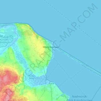
Naam: Topografische kaart Władysławowo, hoogte, reliëf.
Locatie: Władysławowo, Puck County, Pomeranian Voivodeship, Poland (54.72948 18.19442 54.83642 18.52934)
Gemiddelde hoogte: 11 m
Minimale hoogte: -5 m
Maximale hoogte: 108 m
Andere topografische kaarten
Klik op een kaart om zijn topografie, zijn hoogte en zijn reliëf te bekijken.
Sławoszyno
Poland > Pomeranian Voivodeship > Puck County
Sławoszyno, gmina Krokowa, Puck County, Pomeranian Voivodeship, 84-110, Poland
Gemiddelde hoogte: 23 m
Sławutowo
Poland > Pomeranian Voivodeship > Puck County
Sławutowo, gmina Puck, Puck County, Pomeranian Voivodeship, 84-122, Poland
Gemiddelde hoogte: 51 m
Kartoszyno
Poland > Pomeranian Voivodeship > Puck County
Kartoszyno, gmina Krokowa, Puck County, Pomeranian Voivodeship, 84-110, Poland
Gemiddelde hoogte: 36 m
Żelistrzewo
Poland > Pomeranian Voivodeship > Puck County
Żelistrzewo, gmina Puck, Puck County, Pomeranian Voivodeship, 84-122, Poland
Gemiddelde hoogte: 25 m
Puck County
Poland > Pomeranian Voivodeship > Puck County
Puck County, Pomeranian Voivodeship, Poland
Gemiddelde hoogte: 44 m