
Topografische kaart Tempe
Interactieve kaart
Klik op de kaart om de hoogte weer te geven.
Over deze kaart
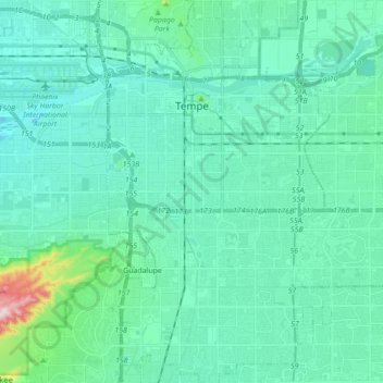
Naam: Topografische kaart Tempe, hoogte, reliëf.
Locatie: Tempe, Maricopa County, Arizona, United States (33.32004 -111.97849 33.46533 -111.87743)
Gemiddelde hoogte: 370 m
Minimale hoogte: 317 m
Maximale hoogte: 708 m
Tempe is generally flat, except for Hayden Butte (generally known as A-Mountain for Arizona State University's "A" logo located on its south face), located next to Sun Devil Stadium, Twin Buttes and Bell Butte on the western edge of Tempe, and Papago Park northwest of Tempe, inside Phoenix. Elevation ranges from 1,140 feet (350 m) at Tempe Town Lake to 1,495 feet (456 m) atop Hayden Butte.
Andere topografische kaarten
Klik op een kaart om zijn topografie, zijn hoogte en zijn reliëf te bekijken.
Scottsdale
United States > Arizona > Maricopa County
Scottsdale, Maricopa County, Arizona, United States
Gemiddelde hoogte: 553 m
Tolleson
United States > Arizona > Maricopa County
Tolleson, Maricopa County, Arizona, United States
Gemiddelde hoogte: 310 m
Hollis Park
United States > Arizona > Maricopa County > Tempe
Hollis Park, Tempe, Maricopa County, Arizona, United States
Gemiddelde hoogte: 362 m
Peoria
United States > Arizona > Maricopa County
Peoria, Maricopa County, Arizona, United States
Gemiddelde hoogte: 505 m
Mesa
United States > Arizona > Maricopa County
Mesa, Maricopa County, Arizona, 85201, United States
Gemiddelde hoogte: 399 m
Youngtown
United States > Arizona > Maricopa County
Youngtown, Maricopa County, Arizona, 85363, United States
Gemiddelde hoogte: 341 m
Glendale
United States > Arizona > Maricopa County
Glendale, Maricopa County, Arizona, United States
Gemiddelde hoogte: 380 m
New River
United States > Arizona > Maricopa County > Phoenix
New River, Phoenix, Maricopa County, Arizona, United States
Gemiddelde hoogte: 690 m
Phoenix
United States > Arizona > Maricopa County
Phoenix, Maricopa County, Arizona, United States
Gemiddelde hoogte: 481 m
Mesa
United States > Arizona > Maricopa County
Mesa, Maricopa County, Arizona, United States
Gemiddelde hoogte: 385 m
Avondale
United States > Arizona > Maricopa County
Avondale, Maricopa County, Arizona, United States
Gemiddelde hoogte: 339 m
Litchfield Park
United States > Arizona > Maricopa County
Litchfield Park, Maricopa County, Arizona, United States
Gemiddelde hoogte: 319 m
Chandler
United States > Arizona > Maricopa County
Chandler, Maricopa County, Arizona, United States
Gemiddelde hoogte: 372 m