
Topografische kaart Chucallani / Sachacanto
Interactieve kaart
Klik op de kaart om de hoogte weer te geven.
Over deze kaart
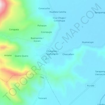
Naam: Topografische kaart Chucallani / Sachacanto, hoogte, reliëf.
Locatie: Chucallani / Sachacanto, Cupi, Melgar, Puno, Perú (-14.92261 -70.88360 -14.88261 -70.84360)
Gemiddelde hoogte: 4.048 m
Minimale hoogte: 3.943 m
Maximale hoogte: 4.575 m
Andere topografische kaarten
Klik op een kaart om zijn topografie, zijn hoogte en zijn reliëf te bekijken.
Santa Lucia
Perú > Puno > Cupi > Santa Lucia
Santa Lucia, Cupi, Provincia de Melgar, Puno, Perú
Gemiddelde hoogte: 3.931 m