
Topografische kaart Double Horn
Interactieve kaart
Klik op de kaart om de hoogte weer te geven.
Over deze kaart
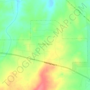
Naam: Topografische kaart Double Horn, hoogte, reliëf.
Locatie: Double Horn, Burnet County, Texas, United States (30.48668 -98.24417 30.50651 -98.20258)
Gemiddelde hoogte: 287 m
Minimale hoogte: 253 m
Maximale hoogte: 329 m
The original settlement of Double Horn was established near the headwaters of Double Horn Creek in 1855, with the creek and town named for an incident where a pioneer found the remains of two bucks with interlocked antlers. It had a post office from 1857 to 1911, a school (the Double Horn School), a cotton gin, and two churches. In 1884, the population was 50; by 1896, this population had halved, and by 1936, only the school remained marked on state road maps. Double Horn had completely disappeared from maps as a separate community by the second half of the 20th century. This location is close to a lightly populated ranching area marked on modern topographic maps as Shovel Mountain.
Andere topografische kaarten
Klik op een kaart om zijn topografie, zijn hoogte en zijn reliëf te bekijken.
Burnet
United States > Texas > Burnet County
Burnet, Burnet County, Texas, United States
Gemiddelde hoogte: 404 m
Highland Haven
United States > Texas > Burnet County
Highland Haven, Burnet County, Texas, United States
Gemiddelde hoogte: 259 m
Meadowlakes
United States > Texas > Burnet County
Meadowlakes, Burnet County, Texas, United States
Gemiddelde hoogte: 241 m
Lake Marble Falls
United States > Texas > Burnet County > Meadowlakes
Lake Marble Falls, Meadowlakes, Burnet County, Texas, United States
Gemiddelde hoogte: 264 m
Bertram
United States > Texas > Burnet County
Bertram, Burnet County, Texas, 78605, United States
Gemiddelde hoogte: 372 m
Inks Lake State Park
United States > Texas > Burnet County > Burnet
Inks Lake State Park, Burnet, Burnet County, Texas, 78611, United States
Gemiddelde hoogte: 294 m
Colorado River
United States > Texas > Burnet County > Granite Shoals
Colorado River, Granite Shoals, Burnet County, Texas, 78639, United States
Gemiddelde hoogte: 302 m
Rocky Point
United States > Texas > Burnet County
Rocky Point, Burnet County, Texas, United States
Gemiddelde hoogte: 322 m
Lake Buchanan
United States > Texas > Burnet County
Lake Buchanan, Burnet County, Texas, United States
Gemiddelde hoogte: 363 m
Spicewood
United States > Texas > Burnet County
Spicewood, Burnet County, Texas, United States
Gemiddelde hoogte: 251 m
Inks Lake
United States > Texas > Burnet County > Laguna Vista
Inks Lake, Laguna Vista, Burnet County, Texas, United States
Gemiddelde hoogte: 299 m
Bertram
United States > Texas > Burnet County > Bertram > Bertram
Bertram, Burnet County, Texas, 78605, United States
Gemiddelde hoogte: 372 m
Marble Falls
United States > Texas > Burnet County > Marble Falls > Marble Falls
Marble Falls, Burnet County, Texas, 76654, United States
Gemiddelde hoogte: 261 m
Spider Mountain
United States > Texas > Burnet County
Spider Mountain, Burnet County, Texas, United States
Gemiddelde hoogte: 342 m
Cottonwood Shores
United States > Texas > Burnet County
Cottonwood Shores, Burnet County, Texas, United States
Gemiddelde hoogte: 247 m
Granite Shoals
United States > Texas > Burnet County
Granite Shoals, Burnet County, Texas, United States
Gemiddelde hoogte: 263 m
Marble Falls
United States > Texas > Burnet County
Marble Falls, Burnet County, Texas, 76654, United States
Gemiddelde hoogte: 278 m
Smithwick
United States > Texas > Burnet County
Smithwick, Burnet County, Texas, United States
Gemiddelde hoogte: 266 m