
Topografische kaart Martinsville
Interactieve kaart
Klik op de kaart om de hoogte weer te geven.
Over deze kaart
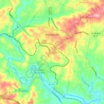
Naam: Topografische kaart Martinsville, hoogte, reliëf.
Locatie: Martinsville, Virginia, United States (36.64381 -79.90408 36.71534 -79.82626)
Gemiddelde hoogte: 259 m
Minimale hoogte: 194 m
Maximale hoogte: 355 m
According to the United States Census Bureau, the city has a total area of 11.0 square miles (28.5 km2), of which 11.0 square miles (28.5 km2) is land and 0.1 square miles (0.3 km2) (0.5%) is water. The north side of the city has the highest average elevation. The east side slopes gradually down to the Smith River on the south side. The west side is hilly. Martinsville is located in the Southern Virginia region near the Virginia–North Carolina state line and is 17 miles (27 km) northwest of Eden, North Carolina, 30 miles (48 km) northwest of Danville, 48 miles (77 km) north of Greensboro, North Carolina. 51 miles (82 km) south of Roanoke, and 54 miles (87 km) northeast of Winston-Salem, North Carolina.
Andere topografische kaarten
Klik op een kaart om zijn topografie, zijn hoogte en zijn reliëf te bekijken.
Thomas Terrace
United States > Virginia > Campbell County
Thomas Terrace, Campbell County, Virginia, United States
Gemiddelde hoogte: 226 m
Good
United States > Virginia > Frederick County
Good, Frederick County, Virginia, 22625, United States
Gemiddelde hoogte: 356 m
Newport News
United States > Virginia > Newport News
Newport News, Virginia, 23607, United States
Gemiddelde hoogte: 4 m
Herndon
United States > Virginia > Fairfax County
Herndon, Fairfax County, Virginia, United States
Gemiddelde hoogte: 111 m
Merrifield
United States > Virginia > Fairfax County
Merrifield, Fairfax County, Virginia, United States
Gemiddelde hoogte: 111 m
Green Spring
United States > Virginia > Frederick County
Green Spring, Frederick County, Virginia, United States
Gemiddelde hoogte: 245 m
Height
United States > Virginia > Buchanan County
Height, Buchanan County, Virginia, 24850, United States
Gemiddelde hoogte: 725 m
Aldie
United States > Virginia > Loudoun County
Aldie, Loudoun County, Virginia, United States
Gemiddelde hoogte: 119 m
Windsor Estates
United States > Virginia > Fairfax County > Franconia
Windsor Estates, Franconia, Fairfax County, Virginia, 22135, United States
Gemiddelde hoogte: 66 m
Carroll County
Carroll County, Virginia, United States
Gemiddelde hoogte: 709 m
Weyers Cave
United States > Virginia > Augusta County > Weyers Cave
Weyers Cave, Augusta County, Virginia, 24486, United States
Gemiddelde hoogte: 364 m
Solsburg
United States > Virginia > Rockingham County > Elkton
Solsburg, Elkton, Rockingham County, Virginia, 22827, United States
Gemiddelde hoogte: 307 m
Sterling
United States > Virginia > Loudoun County
Sterling, Loudoun County, Virginia, 20164, United States
Gemiddelde hoogte: 97 m
Franklin County
Franklin County, Virginia, United States
Gemiddelde hoogte: 384 m
Cape Charles
United States > Virginia > Northampton County > Cape Charles
Cape Charles, Northampton County, Virginia, United States
Gemiddelde hoogte: 2 m
Greenfields
United States > Virginia > Charlottesville
Greenfields, Charlottesville, Virginia, 22901, United States
Gemiddelde hoogte: 136 m
Martinsville
United States > Virginia > Martinsville
Martinsville, Martinsville City, Virginia, United States
Gemiddelde hoogte: 259 m
Big Hill
United States > Virginia > Rockbridge County
Big Hill, Rockbridge County, Virginia, United States
Gemiddelde hoogte: 486 m
Thurman Island
United States > Virginia > Spotsylvania County
Thurman Island, Spotsylvania County, Virginia, United States
Gemiddelde hoogte: 81 m
Chesterfield County
Chesterfield County, Virginia, United States
Gemiddelde hoogte: 63 m
Short Pump
United States > Virginia > Henrico County > Short Pump
Short Pump, Henrico County, Virginia, United States
Gemiddelde hoogte: 75 m
Bennett Springs
United States > Virginia > Roanoke County
Bennett Springs, Roanoke County, Virginia, United States
Gemiddelde hoogte: 502 m
Hacksneck
United States > Virginia > Accomack County
Hacksneck, Accomack County, Virginia, 23358, United States
Gemiddelde hoogte: 1 m
Cheeseman Island
United States > Virginia > Accomack County
Cheeseman Island, Accomack County, Virginia, 21866, United States
Gemiddelde hoogte: 2 m
Blackstone
United States > Virginia > Nottoway County
Blackstone, Nottoway County, Virginia, United States
Gemiddelde hoogte: 122 m
Surprise
United States > Virginia > Culpeper County
Surprise, Culpeper County, Virginia, United States
Gemiddelde hoogte: 135 m
Massies Mill
United States > Virginia > Nelson County
Massies Mill, Nelson County, Virginia, 22954, United States
Gemiddelde hoogte: 251 m
Chester
United States > Virginia > Chesterfield County > Chester
Chester, Chesterfield County, Virginia, 23831, United States
Gemiddelde hoogte: 44 m
Scottdale
United States > Virginia > Richmond
Scottdale, Richmond, Virginia, 23249, United States
Gemiddelde hoogte: 36 m
Painter
United States > Virginia > Accomack County
Painter, Accomack County, Virginia, United States
Gemiddelde hoogte: 10 m
Stony Creek
United States > Virginia > Sussex County
Stony Creek, Sussex County, Virginia, United States
Gemiddelde hoogte: 24 m
Ferndale Park
United States > Virginia > Dinwiddie County
Ferndale Park, Dinwiddie County, Virginia, 23803, United States
Gemiddelde hoogte: 43 m
Beaumont
United States > Virginia > Powhatan County > Beaumont
Beaumont, Powhatan County, Virginia, 23014, United States
Gemiddelde hoogte: 73 m
Hebron
United States > Virginia > Augusta County > Hebron
Hebron, Augusta County, Virginia, United States
Gemiddelde hoogte: 507 m
Glen Allen
United States > Virginia > Glen Allen
Glen Allen, Henrico County, Virginia, United States
Gemiddelde hoogte: 69 m
Springfield
United States > Virginia > Fairfax County > Springfield
Springfield, Fairfax County, Virginia, United States
Gemiddelde hoogte: 68 m
Midlothian
United States > Virginia > Chesterfield County > Midlothian
Midlothian, Chesterfield County, Virginia, 23113-4386, United States
Gemiddelde hoogte: 97 m
Tangier Island
United States > Virginia > Accomack County > Tangier
Tangier Island, Tangier, Accomack County, Virginia, 23440, United States
Gemiddelde hoogte: 2 m
Buckingham County
Buckingham County, Virginia, United States
Gemiddelde hoogte: 156 m
Rosemont
United States > Virginia > Alexandria > Rosemont
Rosemont, Alexandria, Virginia, 22314-1691, United States
Gemiddelde hoogte: 20 m
Henry County
United States > Virginia > Henry County
Henry County, Virginia, United States
Gemiddelde hoogte: 298 m
Greene County
United States > Virginia > Greene County
Greene County, Virginia, United States
Gemiddelde hoogte: 361 m
Jamestown
United States > Virginia > James City County
Jamestown, James City County, Virginia, 23081, United States
Gemiddelde hoogte: 2 m
Stafford County
United States > Virginia > Stafford County
Stafford County, Virginia, United States
Gemiddelde hoogte: 61 m
Falls Church
United States > Virginia > Falls Church
Falls Church, Virginia, United States
Gemiddelde hoogte: 104 m
Fernleigh
United States > Virginia > Richmond > Fernleigh
Fernleigh, Richmond, Virginia, 23235, United States
Gemiddelde hoogte: 77 m
Hurtsville
United States > Virginia > Appomattox County > Hurtsville
Hurtsville, Appomattox County, Virginia, United States
Gemiddelde hoogte: 156 m
Redhead Bay
United States > Virginia > Virginia Beach (city) > Virginia Beach
Redhead Bay, Virginia Beach, Virginia Beach (city), Virginia, United States
Gemiddelde hoogte: 0 m
Indian
United States > Virginia > Tazewell County > Cedar Bluff > Indian
Indian, Cedar Bluff, Tazewell County, Virginia, 24609, United States
Gemiddelde hoogte: 681 m