
Topografische kaart Canadian County
Interactieve kaart
Klik op de kaart om de hoogte weer te geven.
Over deze kaart
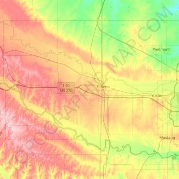
Naam: Topografische kaart Canadian County, hoogte, reliëf.
Locatie: Canadian County, Oklahoma, United States (35.32089 -98.31345 35.72598 -97.67077)
Gemiddelde hoogte: 411 m
Minimale hoogte: 320 m
Maximale hoogte: 523 m
The North Canadian River enters Canadian County near the northwest corner, flows generally southeast towards the middle of the county, then turns southward to leave the county about 8 miles (13 km) north of the southeastern corner. The river length is about 76 miles (122 km). The elevation drops from 1,420 feet (430 m) at the entry to about 1,200 feet (370 m) at the exit. Its named tributaries are Sixmile Creek, Fourmile Creek, Purcell Creek, Shell Creek and Mustang Creek.
Andere topografische kaarten
Klik op een kaart om zijn topografie, zijn hoogte en zijn reliëf te bekijken.
Sulphur
United States > Oklahoma > Murray County
Sulphur, Murray County, Oklahoma, United States
Gemiddelde hoogte: 318 m
Bridge Creek
United States > Oklahoma > Grady County
Bridge Creek, Grady County, Oklahoma, United States
Gemiddelde hoogte: 411 m
Pushmataha County
Pushmataha County, Oklahoma, United States
Gemiddelde hoogte: 240 m
Aqua Park
United States > Oklahoma > Sequoyah County > Paradise Hill
Aqua Park, Paradise Hill, Sequoyah County, Oklahoma, United States
Gemiddelde hoogte: 235 m
Harrison
United States > Oklahoma > Sequoyah County
Harrison, Sequoyah County, Oklahoma, United States
Gemiddelde hoogte: 150 m
Andes Mountain
United States > Oklahoma > Sequoyah County
Andes Mountain, Sequoyah County, Oklahoma, 74945, United States
Gemiddelde hoogte: 202 m
Katie
United States > Oklahoma > Garvin County
Katie, Garvin County, Oklahoma, United States
Gemiddelde hoogte: 291 m
Beckham County
Beckham County, Oklahoma, United States
Gemiddelde hoogte: 602 m
Tulsa
United States > Oklahoma > Tulsa County
Tulsa, Tulsa County, Oklahoma, United States
Gemiddelde hoogte: 221 m
Clayton
United States > Oklahoma > Pushmataha County > Clayton
Clayton, Pushmataha County, Oklahoma, 74536, United States
Gemiddelde hoogte: 188 m
Noble County
United States > Oklahoma > Noble County
Noble County, Oklahoma, United States
Gemiddelde hoogte: 310 m
Stillwater
United States > Oklahoma > Payne County > Stillwater
Stillwater, Payne County, Oklahoma, 74077, United States
Gemiddelde hoogte: 295 m
Garfield County
United States > Oklahoma > Garfield County
Garfield County, Oklahoma, United States
Gemiddelde hoogte: 353 m
Dewar
United States > Oklahoma > Okmulgee County > Dewar
Dewar, Okmulgee County, Oklahoma, 74431, United States
Gemiddelde hoogte: 221 m
Lake Leven
United States > Oklahoma > Oklahoma County > Warr Acres
Lake Leven, Warr Acres, Oklahoma County, Oklahoma, United States
Gemiddelde hoogte: 378 m
Cable Mountain
Cable Mountain, Jackson County, Oklahoma, United States
Gemiddelde hoogte: 428 m
Edmond
United States > Oklahoma > Oklahoma County
Edmond, Oklahoma County, Oklahoma, United States
Gemiddelde hoogte: 340 m
Ardmore
United States > Oklahoma > Ardmore
Ardmore, Carter County, Oklahoma, United States
Gemiddelde hoogte: 258 m
Newcastle
United States > Oklahoma > McClain County > Newcastle
Newcastle, McClain County, Oklahoma, United States
Gemiddelde hoogte: 375 m
Stillwater
United States > Oklahoma > Payne County
Stillwater, Payne County, Oklahoma, United States
Gemiddelde hoogte: 286 m
Denman
United States > Oklahoma > Latimer County > Denman
Denman, Latimer County, Oklahoma, United States
Gemiddelde hoogte: 182 m
Oklahoma County
Oklahoma County, Oklahoma, United States
Gemiddelde hoogte: 354 m
Flynn
United States > Oklahoma > Flynn
Flynn, Oklahoma County, Oklahoma, 73149, United States
Gemiddelde hoogte: 389 m
Peak Hill
Peak Hill, Love County, Oklahoma, 73448, United States
Gemiddelde hoogte: 255 m