
Topografische kaart Carter County
Interactieve kaart
Klik op de kaart om de hoogte weer te geven.
Over deze kaart
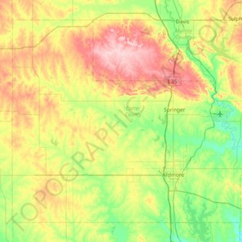
Naam: Topografische kaart Carter County, hoogte, reliëf.
Locatie: Carter County, Oklahoma, United States (34.07091 -97.56266 34.50698 -96.93337)
Gemiddelde hoogte: 285 m
Minimale hoogte: 200 m
Maximale hoogte: 432 m
Andere topografische kaarten
Klik op een kaart om zijn topografie, zijn hoogte en zijn reliëf te bekijken.
Sulphur
United States > Oklahoma > Murray County
Sulphur, Murray County, Oklahoma, United States
Gemiddelde hoogte: 318 m
Bridge Creek
United States > Oklahoma > Grady County
Bridge Creek, Grady County, Oklahoma, United States
Gemiddelde hoogte: 411 m
Pushmataha County
Pushmataha County, Oklahoma, United States
Gemiddelde hoogte: 240 m
Aqua Park
United States > Oklahoma > Sequoyah County > Paradise Hill
Aqua Park, Paradise Hill, Sequoyah County, Oklahoma, United States
Gemiddelde hoogte: 235 m
Harrison
United States > Oklahoma > Sequoyah County
Harrison, Sequoyah County, Oklahoma, United States
Gemiddelde hoogte: 150 m
Andes Mountain
United States > Oklahoma > Sequoyah County
Andes Mountain, Sequoyah County, Oklahoma, 74945, United States
Gemiddelde hoogte: 202 m
Katie
United States > Oklahoma > Garvin County
Katie, Garvin County, Oklahoma, United States
Gemiddelde hoogte: 291 m
Beckham County
Beckham County, Oklahoma, United States
Gemiddelde hoogte: 602 m
Tulsa
United States > Oklahoma > Tulsa County
Tulsa, Tulsa County, Oklahoma, United States
Gemiddelde hoogte: 221 m
Clayton
United States > Oklahoma > Pushmataha County > Clayton
Clayton, Pushmataha County, Oklahoma, 74536, United States
Gemiddelde hoogte: 188 m
Noble County
United States > Oklahoma > Noble County
Noble County, Oklahoma, United States
Gemiddelde hoogte: 310 m
Stillwater
United States > Oklahoma > Payne County > Stillwater
Stillwater, Payne County, Oklahoma, 74077, United States
Gemiddelde hoogte: 295 m
Garfield County
United States > Oklahoma > Garfield County
Garfield County, Oklahoma, United States
Gemiddelde hoogte: 353 m
Dewar
United States > Oklahoma > Okmulgee County > Dewar
Dewar, Okmulgee County, Oklahoma, 74431, United States
Gemiddelde hoogte: 221 m
Lake Leven
United States > Oklahoma > Oklahoma County > Warr Acres
Lake Leven, Warr Acres, Oklahoma County, Oklahoma, United States
Gemiddelde hoogte: 378 m
Cable Mountain
Cable Mountain, Jackson County, Oklahoma, United States
Gemiddelde hoogte: 428 m
Edmond
United States > Oklahoma > Oklahoma County
Edmond, Oklahoma County, Oklahoma, United States
Gemiddelde hoogte: 340 m
Ardmore
United States > Oklahoma > Ardmore
Ardmore, Carter County, Oklahoma, United States
Gemiddelde hoogte: 258 m
Newcastle
United States > Oklahoma > McClain County > Newcastle
Newcastle, McClain County, Oklahoma, United States
Gemiddelde hoogte: 375 m
Canadian County
Canadian County, Oklahoma, United States
Gemiddelde hoogte: 411 m
Stillwater
United States > Oklahoma > Payne County
Stillwater, Payne County, Oklahoma, United States
Gemiddelde hoogte: 286 m
Denman
United States > Oklahoma > Latimer County > Denman
Denman, Latimer County, Oklahoma, United States
Gemiddelde hoogte: 182 m
Oklahoma County
Oklahoma County, Oklahoma, United States
Gemiddelde hoogte: 354 m
Flynn
United States > Oklahoma > Flynn
Flynn, Oklahoma County, Oklahoma, 73149, United States
Gemiddelde hoogte: 389 m
Peak Hill
Peak Hill, Love County, Oklahoma, 73448, United States
Gemiddelde hoogte: 255 m