
Topografische kaart West Frankfort
Interactieve kaart
Klik op de kaart om de hoogte weer te geven.
Over deze kaart
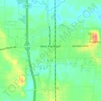
Naam: Topografische kaart West Frankfort, hoogte, reliëf.
Gemiddelde hoogte: 122 m
Minimale hoogte: 108 m
Maximale hoogte: 155 m
The area of West Frankfort formerly known as Frankfort is still sometimes referred to locally as Frankfort Heights or, more commonly, simply as "The Heights", due to its higher elevation relative to the rest of the city. A post office was maintained in Frankfort Heights until its destruction by fire in 2004, making West Frankfort one of the smallest cities in the United States to have two ZIP codes (the other zip code is designated as "Frankfort Heights, Illinois").
Andere topografische kaarten
Klik op een kaart om zijn topografie, zijn hoogte en zijn reliëf te bekijken.
Benton Park
United States > Illinois > Franklin County > Benton
Benton Park, Benton, Franklin County, Illinois, 62897, United States
Gemiddelde hoogte: 138 m
Benton
United States > Illinois > Franklin County
Benton, Franklin County, Illinois, 62812, United States
Gemiddelde hoogte: 132 m
Christopher
United States > Illinois > Franklin County
Christopher, Franklin County, Illinois, 62822, United States
Gemiddelde hoogte: 130 m
Thompsonville
United States > Illinois > Franklin County
Thompsonville, Franklin County, Illinois, United States
Gemiddelde hoogte: 147 m
Royalton
United States > Illinois > Franklin County > Royalton
Royalton, Franklin County, Illinois, United States
Gemiddelde hoogte: 122 m
Rend Lake
United States > Illinois > Franklin County
Rend Lake, Franklin County, Illinois, United States
Gemiddelde hoogte: 132 m