
Topografische kaart Rend Lake
Interactieve kaart
Klik op de kaart om de hoogte weer te geven.
Over deze kaart
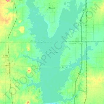
Naam: Topografische kaart Rend Lake, hoogte, reliëf.
Locatie: Rend Lake, Franklin County, Illinois, United States (38.03493 -89.01368 38.18750 -88.89034)
Gemiddelde hoogte: 132 m
Minimale hoogte: 116 m
Maximale hoogte: 178 m
Andere topografische kaarten
Klik op een kaart om zijn topografie, zijn hoogte en zijn reliëf te bekijken.
Benton Park
United States > Illinois > Franklin County > Benton
Benton Park, Benton, Franklin County, Illinois, 62897, United States
Gemiddelde hoogte: 138 m
Benton
United States > Illinois > Franklin County
Benton, Franklin County, Illinois, 62812, United States
Gemiddelde hoogte: 132 m
Christopher
United States > Illinois > Franklin County
Christopher, Franklin County, Illinois, 62822, United States
Gemiddelde hoogte: 130 m
West Frankfort
United States > Illinois > Franklin County
West Frankfort, Franklin County, Illinois, 62896, United States
Gemiddelde hoogte: 122 m
Thompsonville
United States > Illinois > Franklin County
Thompsonville, Franklin County, Illinois, United States
Gemiddelde hoogte: 147 m
Royalton
United States > Illinois > Franklin County > Royalton
Royalton, Franklin County, Illinois, United States
Gemiddelde hoogte: 122 m