
Topografische kaart Mauna Loa
Interactieve kaart
Klik op de kaart om de hoogte weer te geven.
Over deze kaart
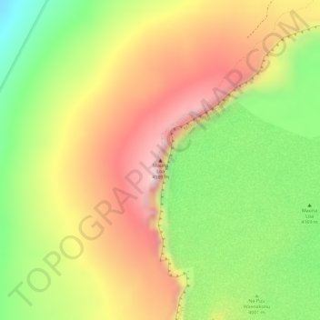
Naam: Topografische kaart Mauna Loa, hoogte, reliëf.
Locatie: Mauna Loa, Hawaiʻi County, Hawaii, United States (19.47548 -155.60575 19.47558 -155.60565)
Gemiddelde hoogte: 4.037 m
Minimale hoogte: 3.860 m
Maximale hoogte: 4.184 m
Mauna Loa is the largest subaerial and second largest overall volcano in the world (behind Tamu Massif), covering a land area of 5,271 km2 (2,035 sq mi) and spans a maximum width of 120 km (75 mi). Consisting of approximately 65,000 to 80,000 km3 (15,600 to 19,200 cu mi) of solid rock, it makes up more than half of the surface area of the island of Hawaiʻi. Combining the volcano's extensive submarine flanks (5,000 m (16,400 ft) to the sea floor) and 4,170 m (13,680 ft) subaerial height, Mauna Loa rises 9,170 m (30,085 ft) from base to summit, greater than the 8,848 m or 29,029 ft elevation of Mount Everest from sea level to its summit. In addition, much of the mountain is invisible even underwater: its mass depresses the crust beneath it by another 8 km (5 mi), in the shape of an inverse mountain, meaning the total height of Mauna Loa from the start of its eruptive history is about 17,170 m (56,000 ft).
Andere topografische kaarten
Klik op een kaart om zijn topografie, zijn hoogte en zijn reliëf te bekijken.
Kailua-Kona
United States > Hawaii > Hawaiʻi County
Kailua-Kona, Hawaiʻi County, Hawaii, 96840, United States
Gemiddelde hoogte: 100 m
Volcano
United States > Hawaii > Hawaiʻi County > Volcano
Volcano, Hawaiʻi County, Hawaii, United States
Gemiddelde hoogte: 1.219 m
Kailua CDP
United States > Hawaii > Hawaiʻi County
Kailua CDP, Hawaiʻi County, Hawaii, United States
Gemiddelde hoogte: 321 m
Waiakea Uka Park
United States > Hawaii > Hawaiʻi County > Hilo CDP
Waiakea Uka Park, Hilo CDP, Hawaiʻi County, Hawaii, United States
Gemiddelde hoogte: 210 m
Kahaluu-Keauhou CDP
United States > Hawaii > Hawaiʻi County
Kahaluu-Keauhou CDP, Hawaiʻi County, Hawaii, United States
Gemiddelde hoogte: 156 m
Waimea/Kamuela CDP
United States > Hawaii > Hawaiʻi County
Waimea/Kamuela CDP, Hawaiʻi County, Hawaii, United States
Gemiddelde hoogte: 876 m
Pahala CDP
United States > Hawaii > Hawaiʻi County
Pahala CDP, Hawaiʻi County, Hawaii, 96777, United States
Gemiddelde hoogte: 254 m
Captain Cook
United States > Hawaii > Hawaiʻi County
Captain Cook, Hawaiʻi County, Hawaii, 96750, United States
Gemiddelde hoogte: 369 m
Rainbow Falls
United States > Hawaii > Hawaiʻi County > Hilo CDP
Rainbow Falls, Hilo CDP, Hawaiʻi County, Hawaii, 96720, United States
Gemiddelde hoogte: 136 m
Pahoa CDP
United States > Hawaii > Hawaiʻi County
Pahoa CDP, Hawaiʻi County, Hawaii, United States
Gemiddelde hoogte: 192 m
Hawai'i Volcanoes National Park
United States > Hawaii > Hawaiʻi County
Hawai'i Volcanoes National Park, Hawaiʻi County, Hawaii, 96718, United States
Gemiddelde hoogte: 688 m
Hamakua
United States > Hawaii > Hawaiʻi County
Hamakua, Hawaiʻi County, Hawaii, United States
Gemiddelde hoogte: 843 m
Mauna Kea
United States > Hawaii > Hawaiʻi County
Mauna Kea, Hawaiʻi County, Hawaii, United States
Gemiddelde hoogte: 3.978 m
Waikui
United States > Hawaii > Hawaiʻi County > Waikui
Waikui, Hawaiʻi County, Hawaii, United States
Gemiddelde hoogte: 180 m
Waikoloa Village
United States > Hawaii > Hawaiʻi County
Waikoloa Village, Hawaiʻi County, Hawaii, United States
Gemiddelde hoogte: 284 m
Mauna Loa
United States > Hawaii > Hawaiʻi County
Mauna Loa, Hawaiʻi County, Hawaii, United States
Gemiddelde hoogte: 4.012 m
Kohala
United States > Hawaii > Hawaiʻi County
Kohala, Hawaiʻi County, Hawaii, United States
Gemiddelde hoogte: 1.489 m
Hilo
United States > Hawaii > Hawaiʻi County
Hilo, Hawaiʻi County, Hawaii, 96720, United States
Gemiddelde hoogte: 193 m