
Topografische kaart Kohala
Interactieve kaart
Klik op de kaart om de hoogte weer te geven.
Over deze kaart
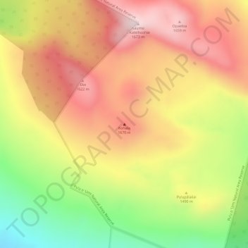
Naam: Topografische kaart Kohala, hoogte, reliëf.
Locatie: Kohala, Hawaiʻi County, Hawaii, United States (20.07494 -155.71874 20.07504 -155.71864)
Gemiddelde hoogte: 1.489 m
Minimale hoogte: 1.233 m
Maximale hoogte: 1.665 m
In Kohala, the numerous dikes near the summit inhibit groundwater from seeping downslope to the northeast, where it naturally wants to go. Rather, the Kohala dike complex guides it northwest or southeast, down the axis of the rift zones, just like the surface water. On the other hand, the three smaller valleys between the large ones - Honopue, Honokea, and Honokane Iki - as well as the many smaller gulches which are not yet valleys, are deprived of groundwater by the orientation of the rift zone and its dikes. Without the large amount of water that is received by the bigger valleys, these valleys grow far more slowly. Due to its topography as essentially a flat crater floor surrounded by cones and fault scarps, the main caldera is affected relatively little by erosion from water.
Andere topografische kaarten
Klik op een kaart om zijn topografie, zijn hoogte en zijn reliëf te bekijken.
Kailua-Kona
United States > Hawaii > Hawaiʻi County
Kailua-Kona, Hawaiʻi County, Hawaii, 96840, United States
Gemiddelde hoogte: 100 m
Volcano
United States > Hawaii > Hawaiʻi County > Volcano
Volcano, Hawaiʻi County, Hawaii, United States
Gemiddelde hoogte: 1.219 m
Kailua
United States > Hawaii > Hawaiʻi County
Kailua, Hawaiʻi County, Hawaii, United States
Gemiddelde hoogte: 321 m
Waiakea Uka Park
United States > Hawaii > Hawaiʻi County > Hilo CDP
Waiakea Uka Park, Hilo CDP, Hawaiʻi County, Hawaii, United States
Gemiddelde hoogte: 210 m
Kahaluu-Keauhou CDP
United States > Hawaii > Hawaiʻi County
Kahaluu-Keauhou CDP, Hawaiʻi County, Hawaii, United States
Gemiddelde hoogte: 156 m
Waimea/Kamuela CDP
United States > Hawaii > Hawaiʻi County
Waimea/Kamuela CDP, Hawaiʻi County, Hawaii, United States
Gemiddelde hoogte: 876 m
Pahala CDP
United States > Hawaii > Hawaiʻi County
Pahala CDP, Hawaiʻi County, Hawaii, 96777, United States
Gemiddelde hoogte: 254 m
Captain Cook
United States > Hawaii > Hawaiʻi County
Captain Cook, Hawaiʻi County, Hawaii, 96750, United States
Gemiddelde hoogte: 369 m
Rainbow Falls
United States > Hawaii > Hawaiʻi County > Hilo CDP
Rainbow Falls, Hilo CDP, Hawaiʻi County, Hawaii, 96720, United States
Gemiddelde hoogte: 136 m
Pahoa CDP
United States > Hawaii > Hawaiʻi County
Pahoa CDP, Hawaiʻi County, Hawaii, United States
Gemiddelde hoogte: 192 m
Hawai'i Volcanoes National Park
United States > Hawaii > Hawaiʻi County
Hawai'i Volcanoes National Park, Hawaiʻi County, Hawaii, 96718, United States
Gemiddelde hoogte: 688 m
Mauna Loa
United States > Hawaii > Hawaiʻi County
Mauna Loa, Hawaiʻi County, Hawaii, United States
Gemiddelde hoogte: 4.037 m
Hamakua
United States > Hawaii > Hawaiʻi County
Hamakua, Hawaiʻi County, Hawaii, United States
Gemiddelde hoogte: 843 m
Mauna Kea
United States > Hawaii > Hawaiʻi County
Mauna Kea, Hawaiʻi County, Hawaii, United States
Gemiddelde hoogte: 3.978 m
Waikui
United States > Hawaii > Hawaiʻi County > Waikui
Waikui, Hawaiʻi County, Hawaii, United States
Gemiddelde hoogte: 180 m
Waikoloa Village
United States > Hawaii > Hawaiʻi County
Waikoloa Village, Hawaiʻi County, Hawaii, United States
Gemiddelde hoogte: 284 m
Mauna Loa
United States > Hawaii > Hawaiʻi County
Mauna Loa, Hawaiʻi County, Hawaii, United States
Gemiddelde hoogte: 4.012 m
Hilo
United States > Hawaii > Hawaiʻi County
Hilo, Hawaiʻi County, Hawaii, 96720, United States
Gemiddelde hoogte: 193 m