
Topografische kaart Lanesborough
Interactieve kaart
Klik op de kaart om de hoogte weer te geven.
Over deze kaart
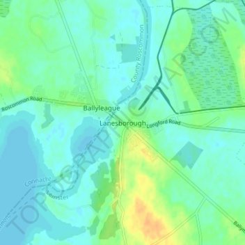
Naam: Topografische kaart Lanesborough, hoogte, reliëf.
Gemiddelde hoogte: 41 m
Minimale hoogte: 34 m
Maximale hoogte: 61 m
Andere topografische kaarten
Klik op een kaart om zijn topografie, zijn hoogte en zijn reliëf te bekijken.
Breany
Breany, Ardagh East ED, Ballymahon Municipal District, County Longford, Leinster, Ireland
Gemiddelde hoogte: 91 m
Lissardowlan
Lissardowlan, Corboy ED, Longford Municipal District, County Longford, Leinster, Ireland
Gemiddelde hoogte: 79 m
Annagh More
Annagh More, Mountdavis ED, Ballymahon Municipal District, County Longford, Leinster, Ireland
Gemiddelde hoogte: 47 m
Laughil
Laughil, Ardagh West ED, Ballymahon Municipal District, County Longford, Leinster, Ireland
Gemiddelde hoogte: 81 m
Barragh More
Barragh More, Drumlish ED, Granard Municipal District, County Longford, Leinster, Ireland
Gemiddelde hoogte: 63 m
Cleggill
Cleggill, Caldragh ED, Longford Municipal District, County Longford, Leinster, Ireland
Gemiddelde hoogte: 48 m
Edgeworthstown
Edgeworthstown, Edgeworthstown ED, Ballymahon Municipal District, County Longford, Leinster, N39 AH64, Ireland
Gemiddelde hoogte: 94 m
Wood Town
Wood Town, Cloonmore, Killashee ED, Ballymahon Municipal District, County Longford, Leinster, Ireland
Gemiddelde hoogte: 46 m
Kilshruley
Ireland > County Longford > Kilshruley
Kilshruley, Ballinalee ED, Granard Municipal District, County Longford, Leinster, Ireland
Gemiddelde hoogte: 66 m
Cloonsheerin
Ireland > County Longford > Cloonsheerin
Cloonsheerin, Killashee ED, Ballymahon Municipal District, County Longford, Leinster, Ireland
Gemiddelde hoogte: 50 m
Drummeel
Ireland > County Longford > Drummeel
Drummeel, Drummeel ED, Granard Municipal District, County Longford, Leinster, Ireland
Gemiddelde hoogte: 72 m
Killyfad
Ireland > County Longford > Killyfad
Killyfad, Cloonee ED, Longford Municipal District, County Longford, Leinster, Ireland
Gemiddelde hoogte: 59 m
Clooneen
Ireland > County Longford > Clooneen
Clooneen, Creevy ED, Granard Municipal District, County Longford, Leinster, Ireland
Gemiddelde hoogte: 92 m
Elfeet Bay
Elfeet Bay, Cashel West ED, Ballymahon Municipal District, County Longford, Leinster, Ireland
Gemiddelde hoogte: 40 m
Creagh
Ireland > County Longford > Creagh
Creagh, Kilcommock ED, Ballymahon Municipal District, County Longford, Leinster, Ireland
Gemiddelde hoogte: 69 m
Longford
Ireland > County Longford > Longford
Longford, County Longford, Leinster, N39 V9W3, Ireland
Gemiddelde hoogte: 57 m
Lough Gowna
Lough Gowna, Granard Municipal District, County Longford, Leinster, Ireland
Gemiddelde hoogte: 80 m
Abbeyshrule
Ireland > County Longford > Abbeyshrule
Abbeyshrule, Agharra ED, Ballymahon Municipal District, County Longford, Leinster, Ireland
Gemiddelde hoogte: 66 m