
Topografische kaart Breany
Interactieve kaart
Klik op de kaart om de hoogte weer te geven.
Over deze kaart
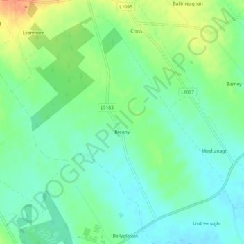
Naam: Topografische kaart Breany, hoogte, reliëf.
Gemiddelde hoogte: 91 m
Minimale hoogte: 76 m
Maximale hoogte: 118 m
Andere topografische kaarten
Klik op een kaart om zijn topografie, zijn hoogte en zijn reliëf te bekijken.
Lanesborough
Lanesborough, Ballymahon Municipal District, County Longford, Leinster, Ireland
Gemiddelde hoogte: 41 m
Lissardowlan
Lissardowlan, Corboy ED, Longford Municipal District, County Longford, Leinster, Ireland
Gemiddelde hoogte: 79 m
Annagh More
Annagh More, Mountdavis ED, Ballymahon Municipal District, County Longford, Leinster, Ireland
Gemiddelde hoogte: 47 m
Laughil
Laughil, Ardagh West ED, Ballymahon Municipal District, County Longford, Leinster, Ireland
Gemiddelde hoogte: 81 m
Barragh More
Barragh More, Drumlish ED, Granard Municipal District, County Longford, Leinster, Ireland
Gemiddelde hoogte: 63 m
Cleggill
Cleggill, Caldragh ED, Longford Municipal District, County Longford, Leinster, Ireland
Gemiddelde hoogte: 48 m
Edgeworthstown
Edgeworthstown, Edgeworthstown ED, Ballymahon Municipal District, County Longford, Leinster, N39 AH64, Ireland
Gemiddelde hoogte: 94 m
Wood Town
Wood Town, Cloonmore, Killashee ED, Ballymahon Municipal District, County Longford, Leinster, Ireland
Gemiddelde hoogte: 46 m
Kilshruley
Ireland > County Longford > Kilshruley
Kilshruley, Ballinalee ED, Granard Municipal District, County Longford, Leinster, Ireland
Gemiddelde hoogte: 66 m
Cloonsheerin
Ireland > County Longford > Cloonsheerin
Cloonsheerin, Killashee ED, Ballymahon Municipal District, County Longford, Leinster, Ireland
Gemiddelde hoogte: 50 m
Drummeel
Ireland > County Longford > Drummeel
Drummeel, Drummeel ED, Granard Municipal District, County Longford, Leinster, Ireland
Gemiddelde hoogte: 72 m
Killyfad
Ireland > County Longford > Killyfad
Killyfad, Cloonee ED, Longford Municipal District, County Longford, Leinster, Ireland
Gemiddelde hoogte: 59 m
Clooneen
Ireland > County Longford > Clooneen
Clooneen, Creevy ED, Granard Municipal District, County Longford, Leinster, Ireland
Gemiddelde hoogte: 92 m
Elfeet Bay
Elfeet Bay, Cashel West ED, Ballymahon Municipal District, County Longford, Leinster, Ireland
Gemiddelde hoogte: 40 m
Creagh
Ireland > County Longford > Creagh
Creagh, Kilcommock ED, Ballymahon Municipal District, County Longford, Leinster, Ireland
Gemiddelde hoogte: 69 m
Longford
Ireland > County Longford > Longford
Longford, County Longford, Leinster, N39 V9W3, Ireland
Gemiddelde hoogte: 57 m
Lough Gowna
Lough Gowna, Granard Municipal District, County Longford, Leinster, Ireland
Gemiddelde hoogte: 80 m
Abbeyshrule
Ireland > County Longford > Abbeyshrule
Abbeyshrule, Agharra ED, Ballymahon Municipal District, County Longford, Leinster, Ireland
Gemiddelde hoogte: 66 m