
Topografische kaart Launceston
Interactieve kaart
Klik op de kaart om de hoogte weer te geven.
Over deze kaart
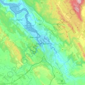
Naam: Topografische kaart Launceston, hoogte, reliëf.
Locatie: Launceston, City of Launceston, Tasmania, Australia (-41.52687 146.97218 -41.33457 147.30525)
Gemiddelde hoogte: 194 m
Minimale hoogte: -3 m
Maximale hoogte: 855 m
Launceston is at 41°26′31″S 147°8′42″E / 41.44194°S 147.14500°E / -41.44194; 147.14500 in the Tamar Valley, Northern Tasmania. The valley was formed by volcanic and glacial forces over 10 million years ago. The city is about 45 kilometres (28 mi) south of the Bass Strait, with its closest neighbour-city being Devonport, about 99 kilometres (62 mi) to the north west. Launceston combines steep (originally heavily wooded) ridges and low-lying areas (originally wetlands – with parts of the suburbs of Inveresk and Invermay below high-tide level). As a result, areas of Launceston are subject to landslip problems, while others are liable to poor drainage and periodic flooding. The topography of the area is not conducive to easy dispersion of airborne pollution, due to the phenomenon of thermal inversion.
Andere topografische kaarten
Klik op een kaart om zijn topografie, zijn hoogte en zijn reliëf te bekijken.
Goulds Country
Goulds Country, Break O'Day, Tasmania, 7216, Australia
Gemiddelde hoogte: 308 m
Vale of Belvoir Conservation Area
Vale of Belvoir Conservation Area, Kentish, Tasmania, Australia
Gemiddelde hoogte: 866 m
Lake Belton
Lake Belton, Derwent Valley, Tasmania, Australia
Gemiddelde hoogte: 1.056 m
Erith Island
Erith Island, Flinders Council, Tasmania, Australia
Gemiddelde hoogte: 23 m
Chicken Island
Chicken Island, Huon Valley, Tasmania, Australia
Gemiddelde hoogte: 4 m
West Hobart
West Hobart, Hobart, City of Hobart, Tasmania, 7000, Australia
Gemiddelde hoogte: 105 m
Mount Nelson
Mount Nelson, Hobart, City of Hobart, Tasmania, 7007, Australia
Gemiddelde hoogte: 198 m
Lake Pedder
Australia > Tasmania > Strathgordon
Lake Pedder, Strathgordon, Derwent Valley, Tasmania, Australia
Gemiddelde hoogte: 366 m
Mersey Forest
Mersey Forest, Meander Valley, Tasmania, Australia
Gemiddelde hoogte: 866 m
Port Arthur
Port Arthur, Tasman, Tasmania, 7182, Australia
Gemiddelde hoogte: 153 m
Highland Waters
Australia > Tasmania > London Lakes
Highland Waters, London Lakes, Central Highlands, Tasmania, Australia
Gemiddelde hoogte: 759 m
Bullock Hill
Bullock Hill, Grove, Huon Valley, Tasmania, Australia
Gemiddelde hoogte: 147 m
Grey Mares Tail
Australia > Tasmania > St Marys
Grey Mares Tail, St Marys, Break O'Day, Tasmania, Australia
Gemiddelde hoogte: 349 m
Anderson Island
Anderson Island, Flinders Council, Tasmania, Australia
Gemiddelde hoogte: 4 m
Flinders Island
Flinders Island, Tasmania, 7255, Australia
Gemiddelde hoogte: 20 m
Macquarie Island
Macquarie Island, Huon Valley, Tasmania, Australia
Gemiddelde hoogte: 20 m
Bruny Island
Australia > Tasmania > Alonnah
Bruny Island, Alonnah, Kingborough, Tasmania, Australia
Gemiddelde hoogte: 59 m
Deal Island
Deal Island, Flinders Council, Tasmania, Australia
Gemiddelde hoogte: 45 m